Typhoon “Betty” Decelerates Over the Philippine Sea
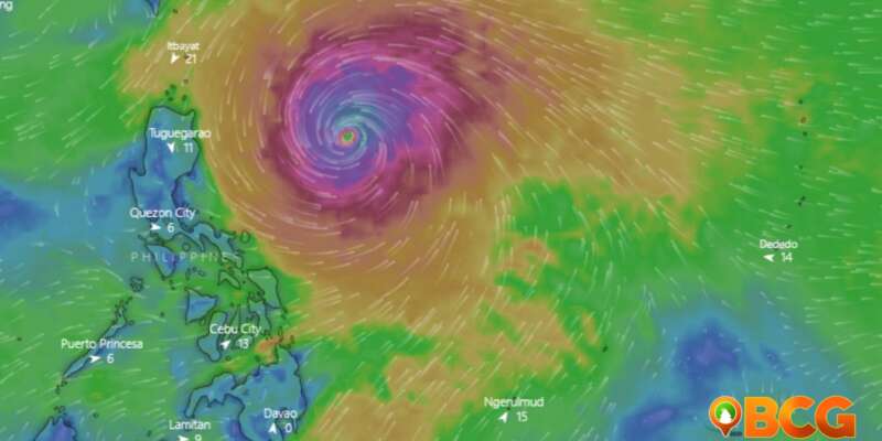
Typhoon Betty continues its westward course over the Philippine Sea, decelerating as it hovers east of Northern Luzon. The approaching typhoon has triggered various levels of advisories and warnings for regions under the Tropical Cyclone Wind Signal (TCWS).
The details surrounding Typhoon Betty’s trajectory, strength, and potential impact have been updated based on the latest available data:
Location of Eye/Center
The center of Typhoon Betty’s eye is estimated to be located approximately 715 km East of Tuguegarao City, Cagayan (17.3 °N, 128.5 °E).
Movement
Currently, the typhoon is moving westward at a speed of 15 km/h.
Strength
Betty is presenting with maximum sustained winds of 175 km/h near its center and gustiness that reaches up to 215 km/h.
Areas under TCWS No. 1
The areas listed below are expected to experience strong winds within the next 36 hours and are thus placed under TCWS No. 1:
- Batanes
- Cagayan, including Babuyan Islands
- Isabela
- Apayao
- Ilocos Norte
- Northern and central portions of Abra
- (Tineg, Lacub, Lagayan, San Juan, Lagangilang, Licuan-Baay, Malibcong, Danglas, La Paz, Dolores, Tayum, Bucay, Sallapadan, Daguioman, Bucloc, Boliney)
- Kalinga
- Eastern and central portions of Mountain Province
- (Sadanga, Barlig, Natonin, Paracelis, Bontoc)
- Eastern and central portions of Ifugao
- (Mayoyao, Aguinaldo, Alfonso Lista, Banaue, Hingyon, Lagawe, Lamut, Kiangan, Asipulo)
- Northern and central portions of Aurora
- (Dilasag, Casiguran, Dinalungan, Dipaculao)
- Quirino
- Northeastern portion of Nueva Vizcaya
- (Kasibu, Quezon, Solano, Bagabag, Diadi, Villaverde, Bayombong, Ambaguio)
Heavy Rainfall Outlook
Forecast accumulated rainfall varies across regions and time periods:
From tomorrow morning to Tuesday morning:
- 100-200 mm: The eastern portion of Babuyan Islands and the northeastern portion of mainland Cagayan.
- 50-100 mm: Batanes, the northwestern portion of mainland Cagayan, and the northern portions of Ilocos Norte and Apayao.
From Tuesday morning to Wednesday morning:
- Greater than 200 mm: Batanes, Babuyan Islands, and the northern portion of Ilocos Norte
- 100-200 mm: The northern portion of mainland Cagayan, the rest of Ilocos Norte, Ilocos Sur, La Union, Abra, and Benguet
- 50-100 mm: Pangasinan and the rest of Cordillera Administrative Region and mainland Cagayan.
From Wednesday morning to Thursday morning:
- Greater than 200 mm: Batanes, Ilocos Sur, the northern portion of La Union, and the northern portion of Benguet
- 100-200 mm: Babuyan Islands, Ilocos Norte, Abra, and the rest of La Union and Benguet
- 50-100 mm: The northern portion of mainland Cagayan, Pangasinan, and the rest of Cordillera Administrative Region
Track and Intensity Outlook
Betty is expected to continue on its west-northwest or northwest trajectory until tomorrow, gradually decelerating. By Tuesday, the typhoon will likely become slow-moving to almost stationary over the waters east of Batanes. It is then projected to move northward or north-northeastward by mid-Wednesday or Thursday towards the sea east of Taiwan.
Throughout the forecast period, Betty is expected to remain as a typhoon, although it is predicted to weaken gradually until Tuesday. A faster weakening rate may be observed as it moves northward or north-northeastward on Wednesday or Thursday due to increasingly unfavorable conditions. Betty may be downgraded to severe tropical storm category on late Thursday or early Friday.


