Typhoon Betty Maintains Strength as it Accelerates Northeastward
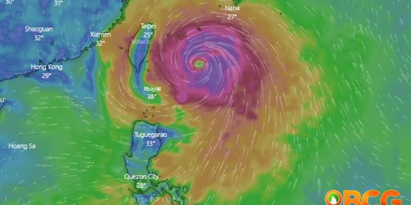
Typhoon Betty continues to maintain its strength as it accelerates northeastward over the sea east-northeast of Batanes. The Philippine Atmospheric, Geophysical, and Astronomical Services Administration (PAGASA) provides the latest update on the typhoon, including its location, intensity, movement, and associated hazards.
Current Details
- Location of Center (4:00 PM): The center of the eye of Typhoon Betty was estimated at 410 km East Northeast of Itbayat, Batanes (22.4°N, 125.4°E).
- Intensity: The typhoon has maximum sustained winds of 120 km/h near the center, gustiness of up to 150 km/h, and a central pressure of 970 hPa.
- Present Movement: Betty is moving northward at 15 km/h.
- Extent of Tropical Cyclone Winds: Strong to typhoon-force winds extend outward up to 550 km from the center.
Tropical Cyclone Wind Signals (TCWS) in Effect
TCWS No. 1
- Wind Threat: Strong winds
- Areas Covered: Batanes and the eastern portion of Babuyan Islands (Calayan Is., Babuyan Is., and Camiguin Is.)
- Warning Lead Time: 36 hours
- Range of Wind Speeds: 39 to 61 km/h (Beaufort 6 to 7)
- Potential Impacts of Winds: Minimal to minor threat to life and property
Hazards Affecting Land Areas
Heavy Rainfall Outlook
The following areas are expected to experience accumulated rainfall from today to tomorrow afternoon:
- 100-200 mm: La Union and Benguet.
- 50-100 mm: Ilocos Norte, Ilocos Sur, and Abra.
Under these conditions, there is a possibility of flooding and rain-induced landslides, especially in areas highly susceptible to these hazards as identified in hazard maps and in localities that have already experienced significant rainfall in recent days. Stay informed about areas affected by occasional to frequent rains from the Southwest Monsoon enhanced by Typhoon Betty through Weather Advisory #5 for Southwest Monsoon issued at 11:00 AM today and the 24-Hour Public Weather Forecast at 4:00 PM today.
Severe Winds
- Wind Signals in some areas of Luzon have been lifted.
- Minimal to minor impacts from strong winds (strong breeze to near gale strength) are possible in areas where Wind Signal No.1 is currently in effect.
- The enhanced Southwest Monsoon will bring occasional to frequent wind gusts over Bicol Region, Western Visayas, Aurora, Quezon, MIMAROPA, Ilocos Region, Cordillera Administrative Region, and Cagayan Valley, which are not under any Wind Signal.
Hazards Affecting Coastal Waters
Under the influence of Typhoon Betty and the enhanced Southwest Monsoon, a marine gale warning remains in effect over the seaboards of Northern Luzon, eastern seaboards of Central Luzon, Southern Luzon, and Visayas. For more information, refer to Gale Warning #9 issued at 5:00 PM today.
Track and Intensity Outlook
- Typhoon Betty is forecasted to gradually accelerate today through tomorrow while generally moving northward over the waters east of Batanes. However, some wobbling in its movement, such as sudden turns to the north-northeast or north-northwest, is possible in the near term, particularly within the next 12 hours.
- Subsequently, the typhoon will turn more northeastward by tomorrow afternoon. It is expected to exit the Philippine Area of Responsibility (PAR) tomorrow afternoon or evening. Once outside the PAR, the tropical cyclone will pass very close to or make landfall in the vicinity of the central Ryukyu Islands by Thursday evening or Friday early morning, specifically Okinawa Island.
- Over the next five days, Typhoon Betty is projected to gradually weaken due to cooler ocean waters caused by upwelling of cooler waters, dry air intrusion, and increasing vertical wind shear. The typhoon may be downgraded to a severe tropical storm tonight or tomorrow morning and further weaken to a tropical storm by Friday evening or Saturday morning.
However, the extent of the effect of dry air intrusion on the typhoon leaves open the possibility of a faster weakening rate within the forecast period. Betty may begin its transition into a post-tropical cyclone on Saturday or Sunday, although this will occur outside the PAR region.
The next tropical cyclone bulletin will be issued at 11:00 PM today.


