
Goring exits, Hanna Enters PAR, 3 Storms enhancing Southwest Monsoon
UPDATE May 20, 2026 11:17 AM:
(adsbygoogle = window.adsbygoogle || []).push({});
Key Developments of STS Hanna: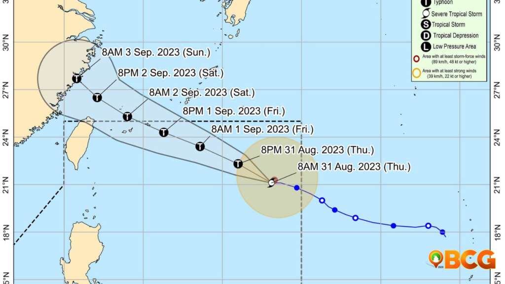
- Location and Movement: Severe Tropical Storm HANNA has been located at 1,160 km East of Extreme Northern Luzon (21.1°N, 133.0°E) and is decelerating westward over the Philippine Sea at a speed of 10 km/h.
- Intensity: It now showcases a maximum sustained wind speed of 110 km/h near its center, with gustiness reaching up to 135 km/h and a central pressure of 985 hPa.
- Tropical Cyclone Wind Signals: Currently, no Wind Signal has been hoisted.
(adsbygoogle = window.adsbygoogle || []).push({});
Potential Hazards by Severe Tropical Storm Hanna
:
- Heavy Rainfall: Enhanced by Super Typhoon SAOLA (Goring) and slightly by HANNA and Tropical Storm KIROGI (outside PAR), the Southwest Monsoon will likely bring occasional to monsoon rains over the western portion of Luzon for the next three days. Areas, especially elevated or mountainous, are cautioned for potential flooding and rain-induced landslides.
- Severe Winds: Areas such as Ilocos Region, Cordillera Administrative Region, Zambales, Bataan, Aurora, Bulacan, Metro Manila, CALABARZON, MIMAROPA, Bicol Region, Western Visayas, and the northern part of Eastern Visayas will experience gusty conditions due to the enhanced Southwest Monsoon.
- Coastal Waters Hazard: While HANNA isn’t predicted to cause rough sea conditions, a Gale Warning has been issued for most seaboards of Luzon and Visayas because of the Southwest Monsoon it slightly enhances. Maritime disruptions like the suspension of sea travel are anticipated.
(adsbygoogle = window.adsbygoogle || []).push({});
Forecast
:
- HANNA is expected to pick up speed and move west northwestward within the next 24 hours, veering northwest throughout the remaining forecast. It’s predicted to stay away from the Philippine landmass, possibly exiting the Philippine Area of Responsibility (PAR) by tomorrow, aiming for the Ryukyu Islands. Post exiting the PAR, HANNA will continue its journey over the East China Sea, making its landfall on China’s east coast by Sunday, where it’s likely to weaken rapidly.
- The storm could intensify till late Saturday or early Sunday, potentially reaching its zenith. There’s a possibility for it to be upgraded to a typhoon within the next 24 hours.
- Benguet, La Union Ilocos Norte, Ilocos Sur, LaUnion, Abra, Apayao, and Nueva Vizcaya are still experiencing light to moderate to at times heavy rains due to the trough of Super Typhoon Goring and the enhanced southwest monsoon.
Public Advisory:
Residents in areas susceptible to the aforementioned hazards must heed local warnings and advisories. It’s vital to prioritize safety, ensuring the protection of both life and property.
(adsbygoogle = window.adsbygoogle || []).push({});
For more information, see our complete guide on List of Open Establishments, Operating Hours and Mode of Service.
How do you feel about this?
Happy
0Sad
0Shocked
0Not Sure
0


