
Tropical Storm Ramil Now Over the Coastal Waters of Alabat, Quezon | Baguio City under Signal No. 2
UPDATE June 3, 2026 10:54 AM:
Issued at 5:00 AM, October 19, 2025 | Valid until the next advisory at 8:00 AM today
Introduction
Tropical Storm Ramil has maintained its strength while moving over the coastal waters of Alabat, Quezon early this morning. The storm continues to bring heavy rainfall, gusty winds, and hazardous sea conditions across several parts of Luzon and the Visayas. As of 5:00 AM, the center of Ramil was located over the coastal waters of Alabat, Quezon (14.1°N, 122.0°E), moving west-northwestward at 25 km/h with maximum sustained winds of 65 km/h and gustiness reaching 90 km/h.
Track and Intensity Outlook
On its current track, Ramil will move west-northwestward or northwestward, making landfall over Quezon Province this morning. It will cross Southern-Central Luzon before emerging over the coastal waters of Pangasinan or Zambales later this afternoon or evening. The system is expected to maintain its strength while traversing land but may slightly weaken due to frictional effects of the terrain. Once over the West Philippine Sea, re-intensification is likely, with Ramil possibly reaching severe tropical storm category before exiting the Philippine Area of Responsibility (PAR) by tomorrow, October 20.
Forecast Positions: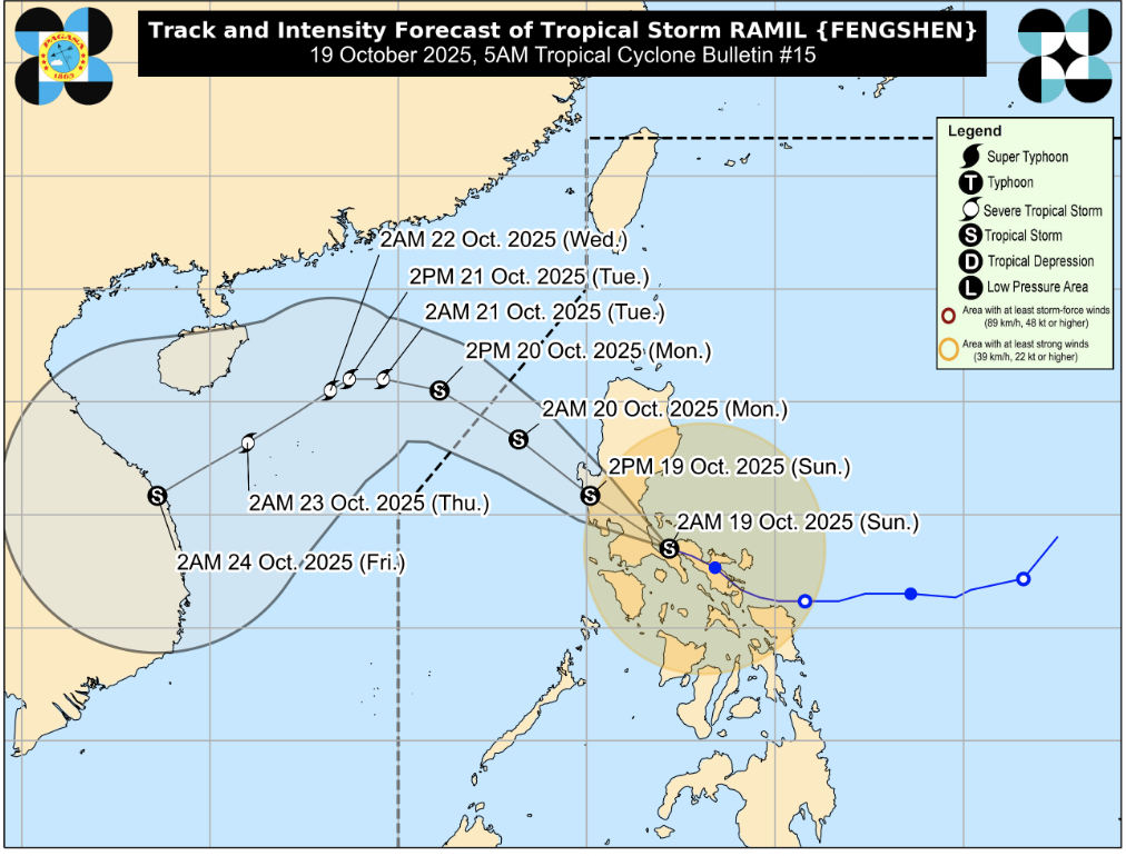
- 2:00 PM, Oct 19: In the vicinity of Palauig, Zambales
- 2:00 AM, Oct 20: 235 km West of Bacnotan, La Union
- 2:00 PM, Oct 20: 465 km West of Sinait, Ilocos Sur (Outside PAR)
- 2:00 AM, Oct 21: 630 km West of Laoag City, Ilocos Norte (Outside PAR)
Hazards Affecting Land Areas
Heavy Rainfall Outlook
Refer to Weather Advisory No. 9 issued at 5:00 AM for rainfall warnings associated with Ramil.
Severe Winds
Moderate to strong winds will continue to affect several regions under Tropical Cyclone Wind Signals (TCWS). Stronger winds are expected in coastal and upland areas, with varying levels of impact depending on signal category.
Areas Under Tropical Cyclone Wind Signals
Tropical Cyclone Wind Signal No. 2
Winds greater than 62 km/h and up to 88 km/h expected within 24 hours.
Luzon:
- Southeastern portion of Quirino (Nagtipunan, Maddela, Aglipay)
- Central and southern portions of Nueva Vizcaya (Alfonso Castañeda, Dupax del Sur, Dupax del Norte, Bambang, Aritao, Kayapa, Santa Fe, Kasibu)
- Central and southern portions of Benguet (Itogon, Bokod, Atok, Kapangan, Tublay, La Trinidad, Baguio City, Tuba, Sablan)
- Central and southern portions of La Union (Rosario, Pugo, Tubao, Santo Tomas, Agoo, Aringay, Caba, Naguilian, Burgos, Bagulin, Bauang, San Fernando City, San Juan, San Gabriel, Bacnotan, Santol, Balaoan, Luna)
- Pangasinan, Aurora, Nueva Ecija, Bulacan, Tarlac, Pampanga
- Northern and central portions of Zambales (Santa Cruz, Candelaria, Masinloc, Palauig, Iba, Botolan, Cabangan)
- Northern portion of Metro Manila (Caloocan, Quezon City, Valenzuela, Marikina, Malabon, Navotas)
- Northern and central portions of Rizal (Rodriguez, San Mateo, Antipolo City, Tanay, Baras)
- Northern portion of Laguna (Santa Maria, Famy, Siniloan)
- Northern and eastern portions of Quezon (General Nakar, Calauag, Tagkawayan, Guinayangan, Quezon, Alabat, Perez, Mauban, Real, Infanta, Atimonan, Plaridel, Gumaca, Lopez) including Polillo Islands
- Camarines Norte, and northwestern portion of Camarines Sur (Del Gallego, Ragay, Lupi, Sipocot)
Expected Impacts:
- Light to moderate damage to high-risk structures
- Partial unroofing of houses made of light materials
- Moderate damage to trees and crops
- Possible power interruptions
Tropical Cyclone Wind Signal No. 1
Winds of 39–61 km/h expected within 36 hours.
Luzon:
- Cagayan including Babuyan Islands, Isabela, rest of Quirino, rest of Nueva Vizcaya
- Apayao, Abra, Kalinga, Mountain Province, Ifugao, rest of Benguet
- Ilocos Norte, Ilocos Sur, rest of La Union, rest of Zambales, Bataan
- Rest of Metro Manila, Quezon, Rizal, Laguna
- Cavite, Batangas, Occidental Mindoro (including Lubang Islands), Oriental Mindoro, Marinduque, Romblon
- Rest of Camarines Sur, Catanduanes, Albay, Sorsogon, northern and central portions of Masbate (Aroroy, Baleno, Mandaon, Milagros, Balud, Masbate City, Mobo, Uson, Dimasalang, Palanas, Cawayan) including Ticao and Burias Islands
Visayas:
- Northern Samar, northern portion of Eastern Samar (Jipapad, San Policarpo, Oras, Arteche, Maslog), and northern portion of Samar (Matuguinao, Calbayog City, Gandara, Santa Margarita, Pagsanghan, Tagapul-an, Almagro, Santo Niño, San Jose de Buan)
Expected Impacts:
- Very light or no damage to low-risk structures
- Light damage to some houses of light materials
- Possible disruption to outdoor activities and sea travel
Coastal Inundation
A minimal to moderate storm surge risk (1.0–2.0 meters) remains possible within 36 hours over low-lying or exposed coastal areas in:
Isabela, Ilocos Norte, Ilocos Sur, La Union, Pangasinan, Zambales, Aurora, Quezon, Marinduque, Camarines Norte, Camarines Sur, Catanduanes, Albay, and Masbate.
Residents are advised to remain alert for possible coastal flooding.
Hazards Affecting Coastal Waters
Gale Warning
In effect over the eastern and western seaboards of Luzon.
- Very rough seas (up to 4.5 m): Isabela, Aurora, Camarines Norte, Polillo Islands, Pangasinan, Zambales, Bataan, Batangas, and the northwestern seaboard of Occidental Mindoro including Lubang Island.
- Rough seas (up to 3.5 m): Northern seaboards of Camarines Sur, northern and eastern seaboards of Catanduanes, northern seaboards of mainland Quezon, and eastern seaboard of mainland Cagayan.
- Moderate seas (up to 2.5 m): La Union, remaining seaboards of Pangasinan and Quezon.
Sea travel remains risky, especially for small vessels and inexperienced mariners.
Precautionary Measures
- Stay indoors and secure loose outdoor items.
- Avoid sea travel and coastal activities.
- Prepare flashlights, first aid kits, and ready-to-eat food.
- Monitor official bulletins from PAGASA and local authorities for updates.
Summary
Tropical Storm Ramil continues to pose threats of heavy rainfall, gusty winds, and dangerous sea conditions over parts of Luzon and the Visayas. Residents, especially in coastal and mountainous areas, are advised to remain alert and take all necessary precautions as the storm traverses Central Luzon today before moving toward the West Philippine Sea.
For more information, see our complete guide on Typhoon Uwan Now Over La Union; Benguet still under Signal No. 4.


