
Goring is now a Super Typhoon as it moves South Southwest
UPDATE June 3, 2026 11:00 AM:
(adsbygoogle = window.adsbygoogle || []).push({});
On 27 August 2023, Super Typhoon Goring intensified, now hovering over the coastal waters of Palanan, Isabela. Here’s an essential breakdown:
Super Typhoon Goring’s Key Metrics:
- Location (as of 4:00 AM): Palanan, Isabela (17.0°N, 123.0°E).
- Intensity: Winds of 185 km/h with gusts up to 230 km/h.
- Movement: South Southwestward at a slow pace.
- Wind Coverage: Up to 260 km from the center.
Tropical Cyclone Wind Signals (TCWS) in Effect:
- TCWS No. 3 (Luzon):
- Wind Threat: Storm-force winds.
- Areas Affected:
- Extreme eastern portion of Isabela:
- Divilacan
- Palanan
- Extreme eastern portion of Isabela:
- Potential Impact: Moderate to significant.
- TCWS No. 2 (Luzon):
- Wind Threat: Gale-force winds.
- Areas Affected:
- Eastern portion of mainland Cagayan:
- Peñablanca
- Baggao
- Gattaran
- Lal-Lo
- Gonzaga
- Santa Teresita
- Buguey
- Santa Ana
- Eastern portion of Isabela:
- Dinapigue
- Ilagan City
- Maconacon
- Cabagan
- Tumauini
- San Pablo
- Benito Soliven
- San Mariano
- Extreme northern portion of Aurora:
- Dilasag
- Casiguran
- Eastern portion of mainland Cagayan:
- TCWS No. 1 (Luzon):
- Wind Threat: Strong winds.
- Areas Affected:
- Babuyan Islands
- Rest of mainland Cagayan
- Rest of Isabela
- Quirino
- Nueva Vizcaya
- Apayao
- Kalinga
- Abra
- Mountain Province
- Ifugao
- Eastern portion of Benguet:
- Bokod
- Buguias
- Kabayan
- Mankayan
- Eastern portion of Ilocos Norte:
- Pagudpud
- Adams
- Vintar
- Carasi
- Nueva Era
- Banna
- Marcos
- Dingras
- Solsona
- Piddig
- Dumalneg
- Bangui
- Northeastern portion of Nueva Ecija:
- Carranglan
- Pantabangan
- Bongabon
- Gabaldon
- Laur
- Rizal
- Northern and central portions of Aurora:
- Dinalungan
- Dipaculao
- Baler
- Maria Aurora
- San Luis
- Polillo Islands
- Calaguas Islands
Land Hazards:
- Heavy Rainfall:
- Today:
- 200 mm: Extreme eastern portion of Isabela.
- 100-200 mm: Eastern portions of mainland Cagayan and Isabela.
- 50-100 mm: Ilocos Region, Apayao, Abra, Benguet, northern Aurora, eastern Nueva Vizcaya, and rest of mainland Cagayan and Isabela.
- Tomorrow:
- 50-100 mm: Eastern parts of Babuyan Islands and mainland Cagayan.
- Tuesday:
- 100-200 mm: Batanes and eastern Babuyan Islands.
- 50-100 mm: Rest of Babuyan Islands and northern mainland Cagayan.
- Today:
Coastal Hazards:
- Gale Warning: Northern and eastern coastal waters of Luzon are on alert, affecting maritime operations.
(adsbygoogle = window.adsbygoogle || []).push({});
Projected Path:
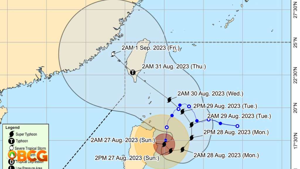
Goring will loop near Cagayan-Isabela, veering northeastward and northward. By Wednesday or early Thursday, a southern Taiwan landfall is expected. The typhoon will weaken upon interacting with Taiwan’s landscape.
Residents are advised to stay vigilant, heed local advisories, and monitor PAGASA updates.
(adsbygoogle = window.adsbygoogle || []).push({});
For more information, see our complete guide on Typhoon Uwan Now Over La Union; Benguet still under Signal No. 4.
How do you feel about this?
Happy
0Sad
1Shocked
0Not Sure
0


