
Tropical Storm Crising may reach Severe Tropical Storm Category later today
UPDATE May 20, 2026 10:59 AM:
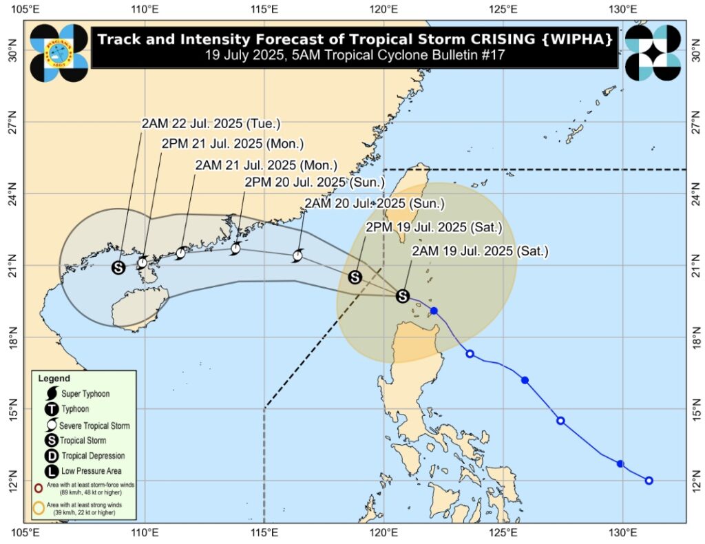
Tropical Storm “CRISING” continues to maintain its strength while moving away from Extreme Northern Luzon.
At 4:00 AM today, its center was located 125 km west northwest of Calayan, Cagayan (19.8°N, 120.4°E).
It is moving west northwestward at 25 km/h, with maximum sustained winds of 85 km/h near the center and gustiness of up to 105 km/h.
It is expected to exit the Philippine Area of Responsibility later this morning or early afternoon.
(adsbygoogle = window.adsbygoogle || []).push({});
HAZARDS AFFECTING LAND AREAS
 Tropical Storm Crising forecast track" width="1024" height="790" class="aligncenter size-large wp-image-54972" />
Heavy Rainfall Outlook:
Refer to Weather Advisory No. 15 issued at 5:00 AM today for detailed heavy rainfall outlook from Tropical Storm CRISING and the Southwest Monsoon.
Severe Winds:
Minor to moderate impacts from gale-force winds are possible in areas under Tropical Cyclone Wind Signal No. 2.
Minimal to minor impacts from strong winds are possible in areas under Tropical Cyclone Wind Signal No. 1.
Tropical Cyclone Wind Signal No. 2
Winds of greater than 62 km/h and up to 88 km/h may be expected in at least 24 hours.
Luzon:
Batanes
Babuyan Islands
Ilocos Norte
Northern portion of Cagayan (Santa Praxedes, Claveria, Sanchez-Mira, Pamplona, Abulug, Ballesteros, Santa Ana, Gonzaga, Santa Teresita, Buguey, Aparri, Camalaniugan, Allacapan, Lal-Lo, Lasam, Rizal, Santo Niño, Gattaran, Alcala)
Northern and central portions of Apayao (Calanasan, Luna, Pudtol, Kabugao, Flora, Santa Marcela)
Northeastern portion of Abra (Tineg, Lagayan)
Tropical Cyclone Wind Signal No. 1
Winds of 39–61 km/h may be expected in at least 36 hours.
Luzon:
The rest of Cagayan
Northern portion of Isabela (Mallig, Divilacan, Quirino, Gamu, Ilagan City, Burgos, San Manuel, Roxas, San Mateo, Aurora, Luna, Cabatuan, Reina Mercedes, Naguilian, Santa Maria, San Pablo, Maconacon, Cabagan, Tumauini, Delfin Albano, Quezon, Santo Tomas)
The rest of Apayao
The rest of Abra
Kalinga
Mountain Province
Ifugao
Northern portion of Benguet (Bakun, Mankayan, Buguias, Kibungan, Kabayan, Atok, Kapangan)
Ilocos Sur
Northern portion of La Union (Bangar, Sudipen, Luna, Balaoan, Santol, San Gabriel, Bacnotan, City of San Fernando, San Juan, Bagulin)
HAZARDS AFFECTING COASTAL WATERS
A Gale Warning is raised over the northern and eastern seaboards of Northern Luzon.
Sea travel is risky for all types of vessels in affected areas.
Mariners of small seacrafts, including motorbancas, are advised not to venture out to sea.
Wave heights may reach:
Up to 6.0 m over Batanes and Babuyan Islands
Up to 4.5 m over the northern seaboard of Ilocos Norte and the remaining seaboards of Cagayan
Up to 4.0 m over Zambales, Bataan, Occidental Mindoro including Lubang Islands, Kalayaan Islands, and the western seaboards of Palawan and Pangasinan
Up to 3.5 m over Isabela, Ilocos Sur, La Union, Batangas, Antique, Iloilo (south), Guimaras (west and south), and Pangasinan (remaining areas)
TRACK AND INTENSITY OUTLOOK
Today, 2:00 PM: 330 km west of Basco, Batanes (outside PAR)
Tomorrow, 2:00 AM: 570 km west of Itbayat, Batanes (outside PAR)
Tomorrow, 2:00 PM: 840 km west of Extreme Northern Luzon (outside PAR)
21 July, 2:00 AM: 1,075 km west of Extreme Northern Luzon (outside PAR)
21 July, 2:00 PM: Near Guangdong Province, China (outside PAR)
22 July, 2:00 AM: 1,345 km west of Extreme Northern Luzon (outside PAR)
Tropical Storm CRISING is expected to intensify further and may reach Severe Tropical Storm category later today.
Source: PAGASA
(adsbygoogle = window.adsbygoogle || []).push({});
For more information, see our complete guide on List of Open Establishments, Operating Hours and Mode of Service.


