Tropical Storm “Chedeng” Holds Strength, Moves Northward Over Philippine Sea
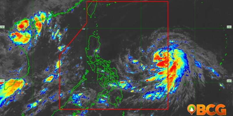
According to the Philippine Atmospheric, Geophysical, and Astronomical Services Administration (PAGASA), Tropical Storm “Chedeng” continues its course over the Philippine Sea, holding steady on its strength and moving in a northward direction.
Current Position and Intensity
At 10:00 AM, Chedeng was located 1,190 km East of Southeastern Luzon. The tropical storm maintains its maximum sustained winds of 75 km/h near the center with gustiness reaching up to 90 km/h, and a central pressure of 998 hPa. It continues to move northward at a speed of 10 km/h. Despite its strength, no tropical cyclone wind signals have been issued as of the moment.
Anticipated Land and Coastal Impact
Heavy Rainfall Outlook
While Chedeng is not expected to bring heavy rainfall directly over any part of the country within the next 3 to 5 days, its current course may still enhance the Southwest Monsoon. The timing and intensity of monsoon rains, particularly over the western parts of the country, are still subject to change, depending on Chedeng’s forecast movement, intensity, and its interaction with other weather systems. The public is advised to stay updated with PAGASA’s advisories for potential monsoon enhancements.
Severe Winds
The issuance of Wind Signals in anticipation of severe cyclone winds is unlikely at this time. However, the Southwest Monsoon may strengthen due to Chedeng, potentially resulting in intermittent wind gusts. The public is advised to stay updated regarding this possibility.
Coastal Water Conditions
Over the next 24 hours, Chedeng is not expected to cause rough sea conditions across the country’s coastal waters.
Future Trajectory and Intensity
Chedeng, while consolidating and intensifying, is forecast to move generally northwestward or west-northwestward today through Friday before shifting more northward or north-northeastward over the weekend. Throughout this forecast period, Chedeng is expected to stay away from the Philippine landmass.
Given the favorable environmental conditions, Chedeng is expected to further intensify over the next 3 to 4 days. It might upgrade to a severe tropical storm category tonight or tomorrow and potentially escalate to a typhoon by Thursday. Rapid intensification is not ruled out, with peak intensity possibly reached by Friday or Saturday.


