Tropical Depression Dodong Accelerates Westward; May reach tropical storm category by tomorrow
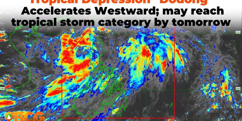
Tropical Depression “Dodong” has accelerated and is currently situated over the coastal waters of Laoag, Ilocos Norte, moving westward. This is according to the tropical cyclone bulletin issued by PAGASA as of 5:00 PM today.
Location of Eye/center
Based on all available data, the center of Tropical Depression Dodong is estimated to be over the coastal waters of Laoag, Ilocos Norte (18.2 °N, 120.3 °E).
Movement and Strength
Dodong is currently moving westward at 20 km/h, with maximum sustained winds of 45 km/h near the center and gustiness reaching up to 75 km/h.
Land Hazards and Heavy Rainfall Forecast
The forecast for accumulated rainfall from this afternoon until tomorrow afternoon remains at 50-100 mm in the following areas:
- Cagayan
- Apayao
- Kalinga
- Abra
- Benguet
- Ilocos Norte
- La Union
- Pangasinan
Areas identified as highly or very highly susceptible in hazard maps, along with localities that have experienced significant rainfall over the past few days, are warned of possible flooding and rain-induced landslides.
Dodong’s Track and Intensity Outlook
Dodong is predicted to move westward or west-northwestward before turning generally northwestward over the West Philippine Sea until it exits the Philippine Area of Responsibility (PAR) by tomorrow evening or on Sunday early morning. After leaving the PAR, Dodong is expected to continue moving west-northwestward over the waters south of southern China.
Dodong may reach tropical storm category by tomorrow while over the West Philippine Sea.
Severe Winds Outlook
Areas where Wind Signal No.1 is currently in effect may experience minimal to minor impacts from strong winds, from strong breeze to near gale strength. The enhanced Southwest Monsoon may also bring gusty conditions to areas not under any wind signal, especially coastal and upland/mountainous areas exposed to the wind.
Affected regions include:
Today:
- MIMAROPA
- Bicol Region
- Western Visayas
- CALABARZON
- Metro Manila
- Central Luzon
- Other areas of Northern Luzon
Tomorrow and Sunday:
- MIMAROPA
- Bicol Region
- Western Visayas
- CALABARZON
- Zambales
- Bataan
- Aurora
- Pangasinan
- La Union
- Isabela
- Benguet
Marine Hazards
Within the next 24 hours, Dodong and the enhanced Southwest Monsoon may generate moderate to rough seas over the eastern (1.5 to 2.5 m) and western (2.0 to 3.5 m) seaboards of Northern Luzon, and the western seaboards of Central and Southern Luzon (2.0 to 3.5 m). Mariners of small seacraft are advised to take precautionary measures when setting sail. Inexperienced mariners or those operating ill-equipped vessels are advised to avoid venturing out to sea under these conditions.
Areas under Tropical Cyclone Wind Signal no. 1
The following areas in Luzon are currently under Tropical Cyclone Wind Signal No. 1:
- Cagayan, including Babuyan Islands
- Apayao
- Ilocos Norte
- Abra
- Ilocos Sur
- Mountain Province
- Kalinga
- Northern portion of Isabela, which includes Mallig, Quezon, Santa Maria, Cabagan, Delfin Albano, Tumauini, Santo Tomas, San Pablo, Maconacon.
Residents in these areas are advised to stay updated with the latest weather bulletins and prepare for possible heavy rainfall and strong winds.

