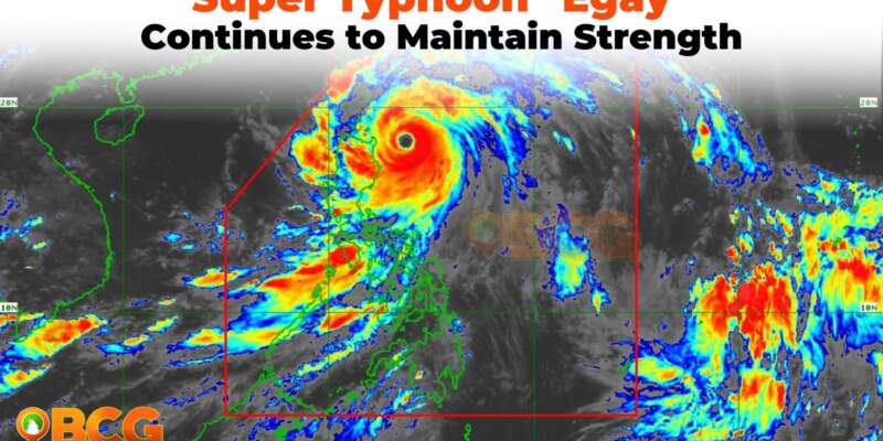
Super Typhoon Egay Continues to Maintain Strength While Moving Northwestward
Typhoon Egay, also known as Doksuri, remains a super typhoon with sustained winds of 185 km/h near the center and gusts of up to 230 km/h. The center of the typhoon’s eye was estimated at 230 km East Northeast of Tuguegarao City, Cagayan, or 240 km East of Aparri, Cagayan (18.1°N, 123.9°E) as of 1:00 PM.
Hazards Affecting Land Areas
The heavy rainfall outlook shows various levels of accumulated rainfall in different regions over the next 24 to 48 hours. The affected areas include the northern portion of mainland Cagayan, Babuyan Islands, Batanes, Ilocos Norte, La Union, Kalinga, Isabela, Zambales, Cordillera Administrative Region, Abra, Ilocos Region, and Benguet. Rainfall in elevated or mountainous areas can lead to flooding and rain-induced landslides, especially in susceptible areas and localities that have already experienced significant rainfall in recent days.
Enhanced Southwest Monsoon
Typhoon Egay is enhancing the Southwest Monsoon, which will bring occasional to monsoon rains over the western portions of Central Luzon, Southern Luzon, and Visayas in the next three days.
Severe Winds
The public is warned about significant to severe impacts from typhoon-force winds under TCWS No. 4 and moderate to significant impacts from storm-force winds under TCWS No. 3. Gale-force winds are also possible under TCWS No. 2, which may result in minor to moderate impacts on life and property. Areas under TCWS No. 1 may experience minimal to minor impacts from strong winds.
Track and Intensity Outlook:
Typhoon Egay is forecast to move northwestward in the next 12 hours before turning generally west northwestward and crossing the Luzon Strait. The current track forecast indicates that Egay may make landfall or pass very close to the Babuyan Islands-northeastern mainland Cagayan area between late evening today and tomorrow morning. There is a possibility of a slight northward or southward shift in this segment of the track (but within the forecast confidence cone), which could result in a landfall or close approach over northern mainland Cagayan or Batanes.
After passing the Babuyan Islands, Egay is forecasted to turn northwestward or north northwestward and pass over the waters south of Taiwan. The storm is then expected to exit the Philippine Area of Responsibility on Thursday morning. Beyond the PAR region, Egay will cross the Taiwan Strait and make landfall in the vicinity of Fujian, China, on Friday morning.
Egay is nearing its peak intensity and may maintain its strength or slightly intensify in the next 12 hours due to a short window of favorable environmental conditions. Afterward, a weakening trend is expected due to increasing interactions with the rugged terrain of Northern Luzon and Taiwan. Further weakening is anticipated outside the PAR region due to an increasingly unfavorable environment and the eventual landfall over the landmass of China.
Areas under Tropical Cyclone Wind Signals
TCWS No. 5
- TCWS No. 5 is in effect for the eastern portion of Babuyan Islands, specifically Camiguin Island. This area may experience typhoon-force winds, with a warning lead time of 12 hours. These winds pose an extreme threat to life and property.
TCWS No. 4
- TCWS No. 4 is in effect for the northeastern portion of mainland Cagayan (Santa Ana and Gonzaga) and the rest of Babuyan Islands.
Typhoon-force winds are also expected in these areas, with a warning lead time of 12 hours. There is a significant to severe threat to life and property.
TCWS No. 3
TCWS No. 3 covers the following areas:
- northeastern portion of Isabela (Divilacan, Maconacon, Palanan, Santa Maria, San Pablo, Santo Tomas, Cabagan, Tumauini),
- the rest of Cagayan, Apayao, eastern portion of Ilocos Norte (Vintar, Adams, Pagudpud, Dumalneg, Nueva Era, Carasi, Bangui, Piddig, Solsona),
- northeastern portion of Kalinga (Rizal, Pinukpuk),
- and Batanes.
Storm-force winds are expected in these areas, with a warning lead time of 18 hours. A moderate to significant threat to life and property is present.
TCWS No. 2
TCWS No. 2 is raised for:
- the rest of Isabela,
- northern and central portions of Aurora (Dilasag, Casiguran, Dinalungan, Dipaculao),
- Quirino,
- the rest of Kalinga,
- northeastern portion of Nueva Vizcaya (Kasibu, Quezon, Diadi, Bagabag, Ambaguio, Villaverde, Solano, Bayombong),
- the rest of Ilocos Norte,
- Ilocos Sur,
- Abra,
- Mountain Province,
- Ifugao,
- and the northern portion of Benguet (Bakun, Mankayan, Buguias, Kabayan, Kibungan, Atok)
- and northern portion of La Union (Bangar, Sudipen, Luna, Balaoan, Santol).
Gale-force winds are expected in these areas, with a warning lead time of 24 hours. There is a minor to moderate threat to life and property.
TCWS No. 1
TCWS No. 1 includes:
- Quezon including Polillo Islands,
- the rest of Aurora,
- the rest of Nueva Vizcaya,
- the rest of Benguet,
- the rest of La Union,
- Nueva Ecija,
- Pangasinan,
- Tarlac,
- Zambales,
- Bulacan,
- Pampanga,
- Bataan,
- Marinduque,
- Cavite,
- Metro Manila,
- Rizal,
- Laguna,
- Batangas,
- Camarines Norte,
- Camarines Sur,
- Albay, and
- Catanduanes.
Strong winds are expected in these areas, with a warning lead time of 36 hours. The potential impacts of winds are minimal to minor threat to life and property.
The next tropical cyclone bulletin will be issued at 5:00 PM by PAGASA today.

