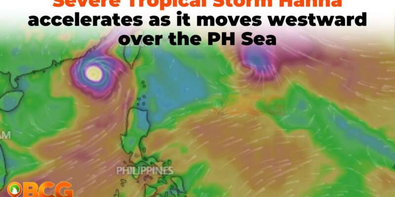
STS Hanna accelerates as it moves westward over the PH Sea
The country is once again bracing for a significant weather event, as Severe Tropical Storm #HannaPH (HAIKUI) charts its course across the Philippine Sea. Issued at 5:00 PM on 31 August 2023, the latest Tropical Cyclone Bulletin paints a detailed picture of Hanna’s trajectory, intensity, and the potential challenges it may pose to certain regions.
- Location & Movement: As of 4:00 PM, Severe Tropical Storm HANNA is located 1,035 km East of Extreme Northern Luzon (21.2°N, 131.8°E). It is currently moving westward over the Philippine Sea at a speed of 15 km/h.
- Intensity: The storm maintains maximum sustained winds of 110 km/h, with gusts up to 135 km/h and a central pressure of 985 hPa.
- Wind Spread: Strong to storm-force winds extend up to 340 km from its center.
Heavy Rainfall
Enhanced by Super Typhoon SAOLA and slightly by HANNA and Severe Tropical Storm KIROGI, the Southwest Monsoon is set to pour occasional to monsoon rains over western Luzon in the coming three days. Elevated or mountainous areas might receive heavier rainfall, heightening the risks of flooding and landslides, especially in hazard-prone zones and regions with recent heavy rains.
Severe Winds
The boosted Southwest Monsoon will persist in bringing gusty conditions to areas including Ilocos Region, Cordillera Administrative Region, Zambales, and more. This holds true for both today, tomorrow, and Saturday.
Coastal Disruptions
Though HANNA is unlikely to induce rough seas, the slightly intensified Southwest Monsoon has triggered a Gale Warning for the majority of Luzon and Visayas’ seaboards. This could lead to disruptions in maritime activities, including potential suspension of sea voyages.
Track and Intensity Outlook
- HANNA is anticipated to shift west-northwestward, exiting the Philippine Area of Responsibility (PAR) by Saturday, approaching the Ryukyu Islands. It could intensify and be classified as a typhoon within the next 12 hours. Notably, it’s expected to remain distant from the Philippine mainland.
- After exiting PAR, HANNA’s path will be west-northwestward until Sunday, later turning northwest. It will continue over the East China Sea, making landfall on China’s east coast on Sunday, where a rapid decline in its strength is forecasted.


