Hanna intensifies into a typhoon
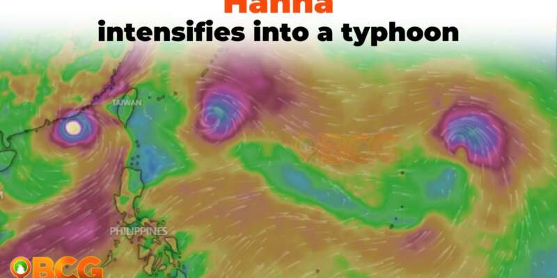
As of the latest advisory issued at 11:00 am, 01 September 2023, the tropical cyclone, previously identified as a severe tropical storm, has now intensified into Typhoon Hanna. The public is urged to stay informed and take necessary precautions.
Current Status of Hanna:
- Location of the Eye: Approximately 785 km East Northeast of Basco, Batanes (22.1 °N, 129.3 °E)
- Movement: Westward at a speed of 20 km/h
- Strength: Sustained winds clocking at 120 km/h near the center with gustiness reaching up to 150 km/h
Hazards Affecting Land Areas:
- Heavy Rainfall Outlook:
- Despite Hanna’s presence, it’s unlikely to directly contribute to heavy rainfall over the country.
- However, the Southwest Monsoon, amplified by Hanna, Typhoon SAOLA (GORING), and Severe Tropical Storm KIROGI, is expected to shower occasional to monsoon rains over the western portion of Luzon in the coming three days.
- Elevated and mountainous regions are particularly at risk, with higher forecasted rainfall. Such conditions may lead to flooding and potential landslides, especially in areas already identified as susceptible and those that have recently witnessed significant rainfall.
- Severe Winds:
- Direct severe winds from Hanna are deemed unlikely.
- However, the enhanced Southwest Monsoon will usher in gusty conditions in the following areas not currently under any Wind Signal:
- Today:
- Batanes
- Ilocos Region
- Cordillera Administrative Region
- Zambales, Bataan, Aurora, Bulacan
- Metro Manila
- CALABARZON, MIMAROPA
- Bicol Region, Western Visayas
- Northern portion of Eastern Visayas
- Tomorrow:
- Same as above, with the addition of Abra and Benguet
- Sunday:
- Batanes, Ilocos Norte, Ilocos Sur, Zambales, Bataan, Bulacan, Aurora, Metro Manila, CALABARZON, MIMAROPA, Bicol Region, and Western Visayas
- Today:
Hazards Affecting Coastal Waters:
- While rough sea conditions linked directly to Hanna are less anticipated, a Gale Warning is currently active for most seaboards of Luzon, Western Visayas, and the Northern Samar seaboard due to the Southwest Monsoon’s influence. Mariners and the general public should anticipate disruptions, including potential suspensions of sea travel in these areas.
Track and Intensity Outlook:
- Hanna’s trajectory is predicted to move either west-northwestward or northwestward.
- The typhoon may make landfall or come very close to the vicinity of the Yaeyama Islands in the Ryukyu archipelago by tomorrow afternoon or evening, and potentially Taiwan by Sunday morning.
- Upon exiting the Philippine Area of Responsibility on Sunday morning, Hanna will shift northwestward, passing over the Taiwan Strait, before making landfall in mainland China by Sunday afternoon or evening.
- Hanna’s peak intensity is expected to be reached tomorrow, before its close encounter or landfall over northern Taiwan. A swift weakening is anticipated after its impact on mainland China on Sunday.
The public and local authorities are advised to remain vigilant, monitor updates, and prioritize safety. The next advisory will be issued at 5:00 PM today.
How do you feel about this?
Happy
0
Sad
0
Shocked
0
Not Sure
0


