
Goring is forecasted to move in a loop and gain strength in the next few days
UPDATE June 3, 2026 11:00 AM:
(adsbygoogle = window.adsbygoogle || []).push({});
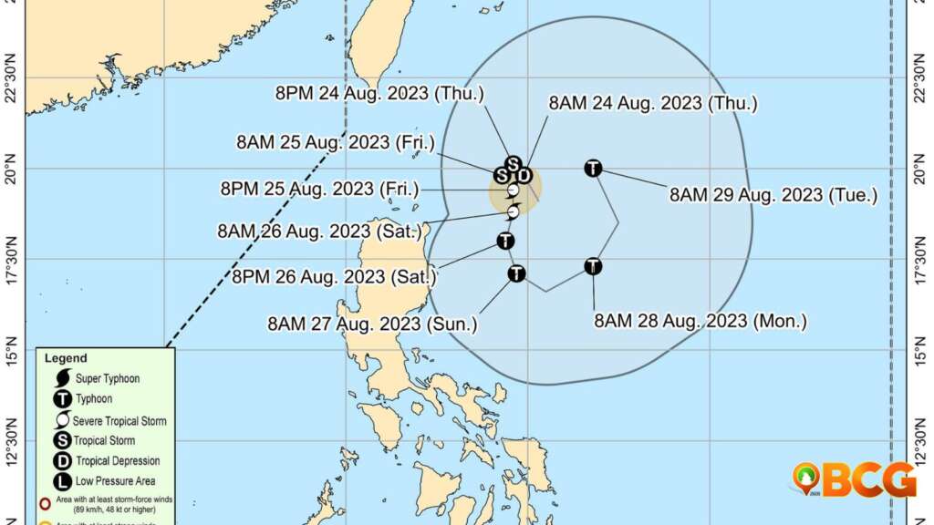
Based on the forecast track, Tropical Depression Goring will move in a loop before leaving the Philippine Are of Responsibility. Tropical Depression Goring is also forecasted to gain strength in the next few days and has a high probability of becoming a typhoon.
Here is the latest information regarding Tropical Depression Goring
Source: PAGASA
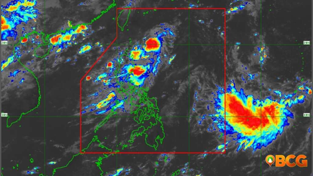
- Tropical Depression Goring remains steady as it moves in a north northwestward direction over the Philippine Sea, east of Basco, Batanes.
- As of 10:00 AM, the center of Goring was located 355 km East Northeast of Calayan, Cagayan, and 300 km East of Basco, Batanes.
- The storm boasts maximum sustained winds of 55 km/h near its center, with gusts reaching up to 70 km/h. Its central pressure is measured at 1004 hPa.
(adsbygoogle = window.adsbygoogle || []).push({});
Movement & Forecast:
Source: DOST-PAGASA
- Goring is currently moving North Northwestward at a speed of 15 km/h.
- Over the next 12 hours, it’s expected to shift northwestward, then turn southward near the eastern coast of Cagayan Valley. In the coming five days, Goring will likely loop and return to a northward direction by late Monday or Tuesday.
- The storm is predicted to intensify, potentially reaching tropical storm status tonight or early tomorrow. By Saturday, it might upgrade to a typhoon. There’s also a chance, albeit volatile, that it could escalate to a super typhoon.
Potential Hazards:
- Rainfall: While heavy rainfall is not expected across the country in the next three days, any westward shift in Goring’s path could result in heavy rains over parts of Cagayan Valley. The Southwest Monsoon might be enhanced by Goring, leading to occasional rains in Central and Southern Luzon.
- Winds: Strong winds extend up to 130 km from the storm’s center. Wind signals for Northern Luzon might be hoisted tonight or tomorrow. The Southwest Monsoon’s potential enhancement could cause gusty conditions in Southern Luzon, Visayas, and parts of Caraga, especially in coastal and mountainous regions.
- Coastal Waters: In the next day, Goring will cause moderate to rough seas over the coastal areas of Extreme Northern Luzon and the northeastern part of mainland Cagayan. Mariners, especially those inexperienced or with ill-equipped vessels, are advised to exercise caution.
Precautions:
- No wind signals have been raised as of now.
- Residents and disaster management teams are urged to stay updated and take necessary precautions.
- Those in high-risk areas should heed local officials’ advice, including potential evacuation orders.
- For specific weather updates in your region, please refer to advisories from your local PAGASA Regional Services Division.
Source: DOST-PAGASA
(adsbygoogle = window.adsbygoogle || []).push({});
For more information, see our complete guide on Typhoon Uwan Now Over La Union; Benguet still under Signal No. 4.
How do you feel about this?
Happy
0Sad
0Shocked
0Not Sure
0


You may also like


0 %