Egay intensifies into a super typhoon
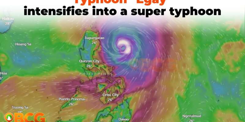
The Philippine Atmospheric, Geophysical, and Astronomical Services Administration (PAGASA) reports that Typhoon Egay has intensified into a super typhoon as it continues its trajectory towards Northern Luzon. The storm, also known by its international name Doksuri, poses significant hazards to land areas and coastal waters.
Location of Eye/Center: The center of the eye of Typhoon Egay was estimated 310 km East of Tuguegarao City, Cagayan (17.6 °N, 124.7 °E).
Movement and Strength: As of the latest advisory, Typhoon Egay is moving northwestward at 10 km/h with maximum sustained winds of 185 km/h near the center and gustiness of up to 230 km/h.
Heavy Rainfall Outlook
Forecasters anticipate heavy rainfall in various regions over the next few days. Today, the eastern portion of Babuyan Islands and the northern portions of mainland Cagayan, Apayao, and Ilocos Norte can expect rainfall of above 200 mm. Ilocos Sur, Abra, and the northern portion of La Union may experience rainfall of 100-200 mm. Tomorrow, Babuyan Islands, Ilocos Norte, and the northern portions of Abra and Ilocos Sur may receive above 200 mm of rainfall. Meanwhile, Batanes, the northwestern portions of mainland Cagayan, the northern portion of Apayao, and the rest of Abra and Ilocos Sur can expect 100-200 mm of rainfall. On Thursday, Batanes may experience rainfall between 50-100 mm.
PAGASA warns that heavy rainfall may lead to flooding and rain-induced landslides, particularly in elevated or mountainous areas. Residents in susceptible regions are advised to take necessary precautions and closely monitor weather updates.
Enhanced Southwest Monsoon:
Typhoon Egay is also enhancing the Southwest Monsoon, bringing occasional to monsoon rains over the western portions of Central Luzon, Southern Luzon, and Visayas in the next three days.
Track and Intensity Outlook
Typhoon Egay is projected to move northwestward in the next 12 hours before turning generally west northwestward and crossing the Luzon Strait. The current track forecast indicates that Egay may make landfall or pass very close to the Babuyan Islands-northeastern mainland Cagayan area between late evening today and tomorrow afternoon. However, slight northward or southward shifts in this segment of the track, within the forecast confidence cone, could result in a landfall or close approach over northern mainland Cagayan or Batanes.
After passing the Babuyan Islands, Egay is forecasted to turn northwestward or north northwestward and pass over the waters south of Taiwan. The storm is then expected to exit the Philippine Area of Responsibility on Thursday morning. Beyond the PAR region, Egay will cross the Taiwan Strait and make landfall in the vicinity of Fujian, China on Friday morning.
Egay is nearing its peak intensity. In the near term, there is a short window of a highly favorable environment that may allow it to either maintain its intensity in the next 12 hours or slightly intensify further. However, a weakening trend is expected to begin afterward due to increasing interactions with the rugged terrain of Northern Luzon and Taiwan. Further weakening is anticipated outside the PAR region due to an increasingly unfavorable environment and the eventual landfall over the landmass of China.
Areas under Tropical Cyclone Wind Signal
TCWS No. 3: Moderate to significant impacts from storm-force winds are possible in areas covered by TCWS No. 3. These areas include:
- Babuyan Islands,
- the northern and eastern portions of mainland Cagayan (Santa Ana, Gonzaga, Peñablanca, Gattaran, Lal-Lo, Alcala, Santa Teresita, Buguey, Aparri, Camalaniugan, Ballesteros, Allacapan, Abulug, Claveria, Pamplona, Sanchez-Mira, Santa Praxedes, Lasam, Baggao, Amulung, Iguig),
- the northeastern portion of Isabela (Divilacan, Maconacon, Palanan),
- and the northern portion of Apayao (Calanasan, Luna, Santa Marcela, Flora, Pudtol).
TCWS No. 2: Minor to moderate impacts from gale-force winds are possible in areas covered by TCWS No. 2. These areas include:
- Batanes,
- the rest of mainland Cagayan,
- the rest of Isabela,
- Quirino,
- the northern portion of Nueva Vizcaya (Kasibu, Quezon, Diadi, Bagabag, Ambaguio, Villaverde, Solano, Bayombong),
- the rest of Apayao,
- Kalinga,
- Abra,
- Mountain Province,
- Ifugao,
- and the northern and central portion of Aurora (Dilasag, Casiguran, Dinalungan, Dipaculao).
TCWS No. 1: Minimal to minor impacts from strong winds are possible in areas covered by TCWS No. 1. These areas include
- La Union,
- Pangasinan,
- the rest of Benguet,
- the rest of Nueva Vizcaya,
- the rest of Aurora,
- Zambales,
- Bataan,
- Nueva Ecija,
- Tarlac,
- Pampanga,
- Bulacan,
- Metro Manila,
- Rizal,
- Laguna,
- Cavite,
- Batangas,
- Quezon,
- Marinduque,
- Camarines Norte,
- Camarines Sur,
- Catanduanes,
- Albay,
- Sorsogon,
- Burias Island, and
- Ticao Island,
- and Northern Samar
Valid for broadcast until the next advisory at 11:00 AM today.

