
Typhoon Jenny Continues to Intensify Over the Philippine Sea
UPDATE June 3, 2026 10:59 AM:
(adsbygoogle = window.adsbygoogle || []).push({});
Current Location: As of 4:00 PM, the center of Typhoon Jenny was estimated to be east of Basco, Batanes.
Intensity: The typhoon boasts maximum sustained winds near its center, with gusts reaching notable speeds. Its central pressure is measured at a significant level.
Movement: Jenny is currently moving in a northwestward direction.
Wind Extent: Strong to typhoon-force winds extend from the typhoon’s center.
(adsbygoogle = window.adsbygoogle || []).push({});
Tropical Cyclone Wind Signals (TCWS) in Effect:
- TCWS No. 1 has been raised, indicating strong winds with a lead time warning.
- Affected areas include:
- Batanes
- Cagayan including Babuyan Islands
- Northern and eastern portions of Isabela (Maconacon, Divilacan, Palanan, Santa Maria, San Pablo, Tumauini, Cabagan, Ilagan City, San Mariano, Santo Tomas, Dinapigue, Benito Soliven, Naguilian, Gamu, Quirino, Delfin Albano, Quezon, Mallig)
- Apayao
- Northern and central portions of Ilocos Norte (Carasi, Vintar, Burgos, Dumalneg, Bangui, Pagudpud, Adams, Nueva Era, Pasuquin, Bacarra, Laoag City, San Nicolas, Sarrat, Piddig, Dingras, Solsona, Marcos)
- Northeastern portion of Abra (Tineg, Lacub, Malibcong)
- Northern portion of Kalinga (Balbalan, Pinukpuk, Rizal, City of Tabuk)
Rainfall Outlook: Heavy rainfall is expected in several areas. Elevated and mountainous regions are at a higher risk of flooding and landslides.
Severe Winds: Coastal and upland/mountainous areas, especially those exposed to winds, may experience enhanced wind conditions.
Coastal Hazards: A Gale Warning has been issued for certain seaboards due to Jenny’s influence. Mariners are advised to exercise caution.
(adsbygoogle = window.adsbygoogle || []).push({});
Track and Intensity Outlook:
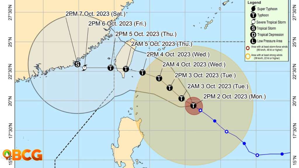
- Jenny is predicted to move generally northwestward until Wednesday before turning west northwestward or westward.
- It is expected to make landfall over the southern portion of Taiwan on Thursday morning and then exit the Philippine Area of Responsibility (PAR) over the Taiwan Strait between Thursday afternoon.
- Jenny is forecast to steadily intensify throughout the forecast period and may reach its peak intensity tomorrow. A slightly weakening trend may begin by late-Wednesday due to potential dry air entrainment and increased wind shear prior to its landfall over Taiwan.
Given the potential hazards associated with Typhoon Jenny, the public and disaster risk reduction and management offices are urged to take necessary precautions. Residents in high-risk areas are advised to heed local evacuation orders and other instructions.
(adsbygoogle = window.adsbygoogle || []).push({});
For more information, see our complete guide on Typhoon Uwan Now Over La Union; Benguet still under Signal No. 4.


