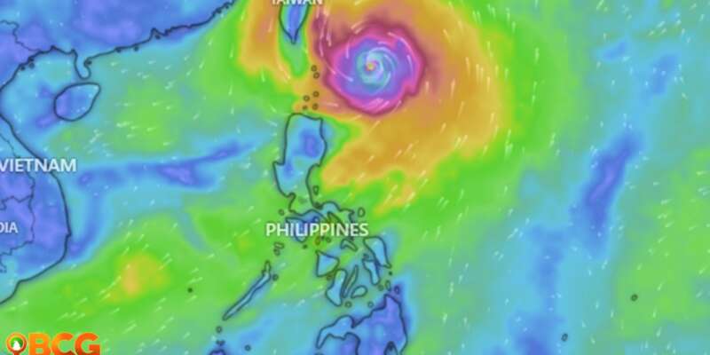
Typhoon Jenny slightly weakened as it moves slowly over the Philippine Sea
Current Status:
- Typhoon Jenny, internationally known as KOINU, has slightly weakened as it decelerates northwestward over the Philippine Sea.
- As of 10:00 AM, the eye of Typhoon Jenny was located approximately 330 km East of Basco, Batanes and 340 km East of Itbayat, Batanes with coordinates 20.7°N, 125.1°E.
- The typhoon boasts maximum sustained winds of 155 km/h near its center, with gusts reaching up to 190 km/h. Its central pressure is measured at 950 hPa.
- Jenny is currently moving northwestward at a speed of 10 km/h.
- Strong to typhoon-force winds extend up to 560 km from the storm’s center.
Tropical Cyclone Wind Signals (TCWS) in Effect:
TCWS No. 2:
- Batanes
TCWS No. 1:
- Cagayan (Luzon)
- Babuyan Islands
- Isabela (Luzon)
- Maconacon
- Divilacan
- Palanan
- Santa Maria
- San Pablo
- Tumauini
- Cabagan
- Ilagan City
- San Mariano
- Santo Tomas
- Dinapigue
- Benito Soliven
- Naguilian
- Gamu
- Quirino
- Delfin Albano
- Quezon
- Mallig
- Apayao (Luzon)
- Abra (Luzon)
- Tineg
- Lacub
- Malibcong
- Kalinga (Luzon)
- Balbalan
- Pinukpuk
- Rizal
- City of Tabuk
- Ilocos Norte (Luzon)
Hazards Affecting Land Areas:
- Heavy Rainfall Outlook: Batanes and Babuyan Islands are expected to receive 50-100 mm of rainfall from today to tomorrow noon. From tomorrow noon to Thursday noon, Batanes may receive 100-200 mm, while Babuyan Islands and the northern part of Ilocos Norte may receive 50-100 mm. Elevated areas may experience higher rainfall, leading to potential flooding and landslides.
- Severe Winds: Coastal and mountainous areas may experience enhanced winds. Wind Signal No. 3 is the most likely highest signal to be hoisted. The Southwest Monsoon, enhanced by Jenny, will bring gusty conditions over several areas not under any Wind Signal.
Hazards Affecting Coastal Waters:
- A Gale Warning is currently in effect for the northern and eastern seaboards of Northern Luzon. Mariners, especially those with small vessels, are advised to exercise caution.
Track and Intensity Outlook:
- Jenny is expected to move northwestward or west-northwestward until tomorrow, then turn westward. It is forecasted to make landfall over southern Taiwan between tomorrow evening and Thursday morning, exiting the Philippine Area of Responsibility (PAR) soon after. Once outside the PAR, Jenny will head towards the coastal waters of southern China.
- The typhoon is expected to weaken due to various factors, including its passage over Taiwan’s rugged terrain and the entrainment of cool dry air from the north.
Advisory: The public and relevant disaster risk reduction and management offices are urged to take necessary precautions. Those residing in high-risk areas should heed local officials’ advice, especially regarding evacuation.
How do you feel about this?
Happy
0
Sad
0
Shocked
0
Not Sure
0


