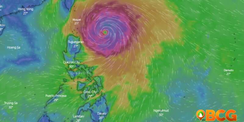
Typhoon #BettyPH Slightly Accelerates Northwestward over the Waters East of Cagayan
As Typhoon #BettyPH continues its northwestward movement over the waters east of Cagayan, authorities are urging residents to take necessary precautions to safeguard lives and property. With maximum sustained winds of 155 km/h near the center and gusts reaching up to 190 km/h, the typhoon poses a significant threat.
Tropical Cyclone Wind Signals have been issued for several areas, indicating the potential impact of gale-force winds. Additionally, heavy rainfall and the possibility of flooding and landslides further elevate the risks.
Location and Intensity
- The center of the eye of Typhoon #BettyPH was estimated at 525 km East of Aparri, Cagayan (18.8°N, 126.6°E) as of 4:00 AM.
- It has maximum sustained winds of 155 km/h near the center, gustiness of up to 190 km/h, and a central pressure of 950 hPa.
Movement and Extent of Tropical Cyclone Winds
- Typhoon #BettyPH is moving northwestward at a speed of 20 km/h.
- Strong to typhoon-force winds extend outward up to 770 km from the center.
Tropical Cyclone Wind Signals (TCWS) in Effect
TCWS No. 2:
- Wind threat: Gale-force winds
- Warning lead time: 24 hours
- Range of wind speeds: 39 to 61 km/h (Beaufort 6 to 7)
- Potential impacts of winds: Minor to moderate threat to life and property
Areas under TCWS No. 2:
- Batanes
- Eastern portion of Babuyan Islands (Babuyan Is., Camiguin Is., Didicas Is., Pamuktan Is.)
- Northeastern portion of mainland Cagayan (Santa Ana)
TCWS No. 1:
- Wind threat: Strong winds
- Warning lead time: 36 hours
- Range of wind speeds: 39 to 61 km/h (Beaufort 6 to 7)
- Potential impacts of winds: Minimal to minor threat to life and property
Areas under TCWS No. 1:
- Rest of Babuyan Islands
- Rest of mainland Cagayan
- Isabela
- Quirino
- Northeastern portion of Nueva Vizcaya (Kasibu, Quezon, Solano, Bagabag, Diadi, Villaverde, Bayombong, Ambaguio)
- Apayao
- Abra
- Kalinga
- Mountain Province
- Ifugao
- Ilocos Norte
- Northern and central portions of Aurora (Dilasag, Casiguran, Dinalungan, Dipaculao, Baler)
- Polillo Islands
- Northern portion of Catanduanes (Caramoran, Viga, Gigmoto, Panganiban, Bagamanoc, Pandan)
- Northeastern portion of Camarines Sur (Caramoan, Garchitorena, Lagonoy, Tinambac, Siruma)
- Northern portion of Camarines Norte (Vinzons, Paracale, Jose Panganiban, Capalonga, Talisay, Daet, Mercedes, Basud)
Hazards Affecting Land Areas
Heavy Rainfall Outlook:
- Forecasted accumulated rainfall from today to tomorrow early morning:
- 50-100 mm: Eastern portion of Babuyan Islands and northeastern portion of mainland Cagayan
- Forecasted accumulated rainfall from tomorrow early morning to Wednesday early morning:
- 100-200 mm: Batanes and eastern portion of Babuyan Islands
- 50-100 mm: Rest of Babuyan Islands, northern portion of mainland Cagayan, Ilocos Norte, Ilocos Sur, La Union, Abra, and Benguet
- Forecasted accumulated rainfall from Wednesday early morning to Thursday early morning:
- 100-200 mm: Batanes, southern portion of Ilocos Sur, La Union, and western portion of Benguet
- 50-100 mm: Babuyan Islands, rest of Ilocos Region, Abra, and rest of Benguet
- Forecasted accumulated rainfall from Thursday early morning to Friday early morning:
- 50-100 mm: Batanes, Ilocos Region, Abra, and western portion of Benguet
Severe Winds:
- Gale-force winds (Wind Signal No. 2) may cause minor to moderate impacts, while strong winds (Wind Signal No. 1) may have minimal to minor impacts.
- Typhoon #BettyPH is expected to enhance the Southwest Monsoon, resulting in occasional gusts in the next 24 hours over specific areas.
Hazards Affecting Coastal Waters
- A marine gale warning remains in effect over various seaboards due to the influence of Typhoon #BettyPH. Please refer to Gale Warning #4 for more details.
Track and Intensity Outlook
- Typhoon #BettyPH is forecasted to move northwestward slowly today, becoming slow-moving or almost stationary from tomorrow to mid-Wednesday over the waters east of Batanes.
- It is expected to turn north-northeastward or northeastward on late Wednesday or Thursday and gradually accelerate towards the waters east of Taiwan and the southern portion of Ryukyu Islands.
- Typhoon #BettyPH may exit the Philippine Area of Responsibility (PAR) on Friday.
- Over the next five days, the typhoon is expected to weaken steadily due to cooler ocean waters and dry air intrusion. It may be downgraded into a severe tropical storm on late Thursday or early Friday and further into a tropical storm on late Friday or early Saturday.
Residents and disaster risk reduction and management offices in susceptible areas are advised to take necessary measures to protect life and property. Follow evacuation and other instructions from local officials, especially in areas prone to flooding and landslides. The next tropical cyclone bulletin will be issued by PAGASA at 11:00 AM today.

