Typhoon Betty Slows Down but Remains a Threat to Northern Luzon
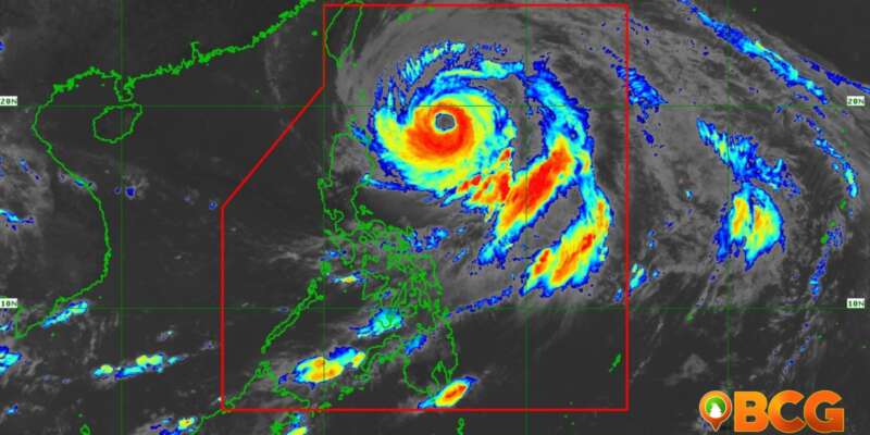
Typhoon Betty, currently moving over the waters east of Cagayan, has slightly decelerated but continues to pose significant threats to parts of Luzon. As of 10:00 AM, the eye of the storm was located approximately 470 km east of Aparri, Cagayan, with sustained winds of 155 km/h and gusts reaching up to 190 km/h.
Although the storm’s speed has slowed, gale-force winds and heavy rainfall are expected to affect large swathes of Luzon, prompting the Philippine Atmospheric, Geophysical and Astronomical Services Administration (PAGASA) to issue Tropical Cyclone Wind Signals (TCWS) for several areas.
Tropical Cyclone Wind Signals in Effect
TCWS No. 2 (Gale-Force Winds)
Luzon areas under this warning include:
- Batanes and the northeastern portion of Cagayan including Santa Ana, Gonzaga, and the Babuyan Islands
TCWS No. 1 (Strong Winds)
Luzon areas under this warning include:
- The rest of mainland Cagayan
- Isabela
- Apayao
- Ilocos Norte
- Abra
- Kalinga
- Mountain Province
- Ifugao
- Northern and central portions of Aurora
- Quirino
- Northeastern portion of Nueva Vizcaya
- Northern portion of Catanduanes
- Northeastern portion of Camarines Sur
- Pollilo Islands
- Northern portion of Camarines Norte
- Northern and central portions of Ilocos Sur
Heavy Rainfall Outlook and Hazards Affecting Land Areas
Betty is also expected to bring heavy rainfall over the coming days, with the eastern portion of Babuyan Islands and the northeastern portion of mainland Cagayan projected to receive 50-100 mm of rain today and tomorrow. Over the next few days, Batanes, Ilocos Region, Abra, and Benguet are also forecast to experience substantial rainfall. These conditions raise the likelihood of flooding and rain-induced landslides, especially in areas highly susceptible to these hazards.
Impact on Southwest Monsoon
In a separate weather advisory issued at 11:00 AM, PAGASA reported that Typhoon Betty is forecast to enhance the Southwest Monsoon over the next three days. This is expected to result in heavy rainfall from 50-100 mm in areas including Occidental Mindoro and Antique starting tomorrow morning.
Occidental Mindoro, Antique, the northwestern portion of Aklan, the western portion of Romblon, and Calamian Islands are forecast to be affected from Wednesday morning to Thursday morning. As with the typhoon, this situation may cause flooding and rain-induced landslides, especially in areas already highly susceptible to these hazards.
The next tropical cyclone bulletin will be issued at 5:00 PM today. The next weather advisory for the Southwest Monsoon, unless there is an intermediate issuance, will be issued at 11:00 PM today.
SOURCE: PAGASA

