LPA Develops into Tropical Depression Chedeng
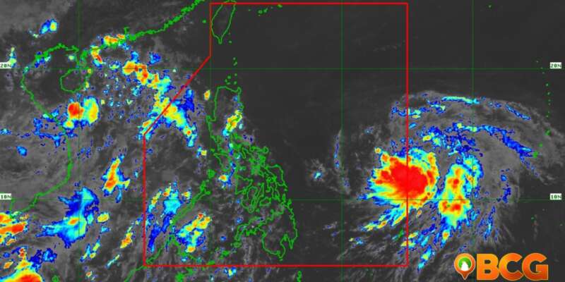
A new weather system has emerged in the Philippine Sea as the Low Pressure Area (LPA) developed into Tropical Depression Chedeng. As of 11:00 AM, the center of Chedeng was estimated at 1,170 km East of Southeastern Luzon (12.9°N, 135.0°E). The tropical depression currently has maximum sustained winds of 45 km/h near the center, with gusts of up to 55 km/h and a central pressure of 1004 hPa. Presently, Chedeng is almost stationary.
Tropical Cyclone Wind Signals (TCWS) have not been hoisted at this time, indicating no immediate threat of strong winds to any area.
Heavy Rainfall Outlook
Chedeng is expected to remain far from the Philippine landmass, suggesting a low possibility of direct heavy rainfall over the country in the next 3 to 5 days. However, it may still contribute to the enhancement of the Southwest Monsoon, which could impact the western portion of the country. The specific areas, timing, and intensity of monsoon rains are subject to change depending on Chedeng’s movement, intensity, and interaction with other weather systems. The public is advised to stay updated on possible Southwest Monsoon enhancement. PAGASA will issue a Weather Advisory should there be an increasing chance of heavy rainfall within the next three days.
Severe Winds
Similarly, Chedeng’s current forecast scenario is not expected to bring severe winds to the Philippine landmass. However, the enhancement of monsoon winds could still result in occasional gusts. As with the heavy rainfall outlook, the potential for enhanced Southwest Monsoon winds may change based on Chedeng’s movement and interaction with other weather systems. Continuous monitoring is advised to stay informed about any possible changes in the Southwest Monsoon.
Coastal Waters
Chedeng poses no immediate threat of rough sea conditions over the coastal waters of the country in the next 24 hours.
Track and Intensity Outlook
Chedeng is projected to gradually intensify and consolidate while moving generally northwestward today, followed by a turn towards the west-northwest tomorrow. The tropical depression will maintain its west-northwestward movement until Thursday and then begin turning towards the northwest on Friday, eventually shifting northward over the weekend. Throughout the forecast period, Chedeng is expected to remain far from the Philippine landmass.
The tropical depression may be upgraded to a tropical storm category by tomorrow and potentially reach typhoon category by Thursday. The peak intensity is expected to occur during the weekend while over the Philippine Sea, east of Northern Luzon.
The next tropical cyclone bulletin will be issued by PAGASA at 5:00 PM today.


