
Low Pressure Area now a Tropical Depression
UPDATE May 13, 2026 11:29 AM:
(adsbygoogle = window.adsbygoogle || []).push({});
One of the two low pressure areas being monitored by PAGASA has developed into a tropical depression. According to the PAGASA weather advisory issued at 5:00AM today October 11, 2022, tropical depression Maymay developed into such at 12:00 midnight and is forecasted to maintain its category in the next 48 hours.
(adsbygoogle = window.adsbygoogle || []).push({});
Location of Tropical Depression Maymay
At 3:00 AM today, tropical depression Maymay was estimated based on all available data 300 km East of Casiguran, Aurora (16.0 °N, 124.9 °E ). It is forecasted to move southwestward at 10km/h.
The forecasted positions of Tropical Depression Maymay
- Oct 11, 2022 02:00 PM – 245 km East of Casiguran, Aurora
- Oct 12, 2022 02:00 AM – 140 km East Southeast of Casiguran, Aurora
- Oct 12, 2022 02:00 PM – 65 km East Southeast of Baler, Aurora
- Oct 13, 2022 02:00 AM – In the vicinity of Pias, Nueva Ecija
- Oct 13, 2022 02:00 PM – 15 km South Southwest of Iba, Zambales
- Oct 14, 2022 02:00 AM – 235 km West of Iba, Zambales
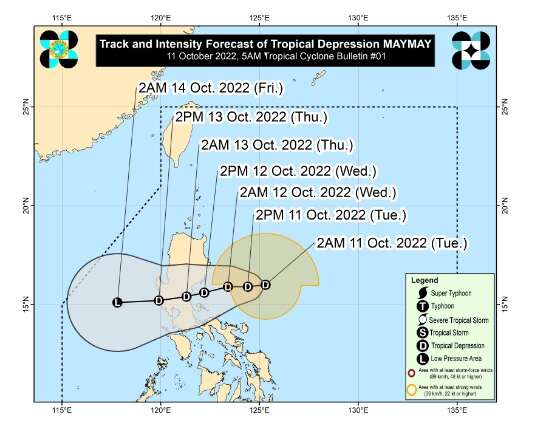
The Forecast Track of Tropical Depression Maymay from PAGASA
(adsbygoogle = window.adsbygoogle || []).push({});
Strength of Tropical Depression Maymay
Tropical depression Maymay has a maximum sustained winds of 45 km/h near the center and gustiness of up to 55 km/h. Today until tomorrow morning, TD Maymay is forecasted to bring moderate to heavy to at times intense rains over Cagayan, Isabela, and Apayao. Light to moderate with at times heavy rains over Batanes, Ilocos Norte, Aurora, and Kalinga.
Tropical Cyclone Wind Signals
Tropical Cyclone Wind Signal number 1 is up in the following areas:
- Isabela
- Quirino
- Nueva Vizcaya
- Aurora
- Nueva Ecija
- and the extreme northern portion of Quezon (General Nakar, Infanta) including Pollilo Islands
(adsbygoogle = window.adsbygoogle || []).push({});
Baguio City Local Weather forecast
Baguio City will experience partly cloudy to cloudy skies with rain showers or thunderstorms due to localized thunderstorms. It is forecasted that Baguio city will experience cloudy skies with rain showers from October 12-13 due to the effects of TD Maymay.
(adsbygoogle = window.adsbygoogle || []).push({});
For more information, see our complete guide on 10 Things You Can Do to Keep Your Cool This Summer.
For more information, see our complete guide on Typhoon Quinta.


