
#BettyPH maintains its strength; TCWS No. 1 hoisted over some areas
UPDATE June 3, 2026 11:04 AM:
Super Typhoon Betty, also known as #BettyPH, continues to sustain its strength as it moves west-northwestward. As of 10:00 AM today, the center of the storm was located approximately 1,170 kilometers east of Central Luzon (16.4°N, 133.1°E).
The powerful storm’s maximum sustained winds were recorded at 195 km/h near the center, gusting up to 240 km/h, and it maintains a central pressure of 915 hPa. The storm is currently moving west-northwestward at a speed of 30 km/h, with strong to typhoon-force winds extending up to 600 kilometers from the center.
(adsbygoogle = window.adsbygoogle || []).push({});
Tropical Cyclone Wind Signal (TCWS)
The first Tropical Cyclone Wind Signal (TCWS No.1) has been hoisted over the following areas:
- The eastern portion of Cagayan (Santa Ana, Gonzaga, Lal-Lo, Gattaran, Baggao, Peñablanca, Santa Teresita, Buguey)
- including Babuyan and Camiguin Islands and the eastern portion of Isabela (Maconacon, Divilacan, Dinapigue, Palanan, San Mariano, Ilagan City, Tumauini, San Pablo, Cabagan)
This warns of the impending impact of strong winds in the area within the next 36 hours.
(adsbygoogle = window.adsbygoogle || []).push({});
Heavy Rainfall Expected
The super typhoon is expected to bring considerable rainfall, with 50-100 mm anticipated in Batanes, Babuyan Islands, and the northern portions of mainland Cagayan, Ilocos Norte, and Apayao from Monday morning to Tuesday morning. Greater volumes of rainfall are expected from Tuesday morning to Wednesday morning, particularly in Batanes, where more than 200 mm is expected.
Even in areas not directly affected by Super Typhoon Betty, enhanced Southwest Monsoon conditions could still bring rain over the western sections of MIMAROPA, Visayas, and Mindanao tomorrow. With this, areas highly or very highly susceptible to flooding and rain-induced landslides are urged to be vigilant, especially those that have experienced substantial rainfall recently.
Potential for Severe Winds and Coastal Hazards
Residents in areas where TCWS No.1 is currently in effect will experience strong winds of strong breeze to near gale strength. Moreover, the enhanced Southwest Monsoon may bring similar conditions with intermittent gusts starting tomorrow evening or early Monday over Visayas, the eastern portions of Central and Southern Luzon, and the northern and eastern portions of Mindanao.
The impending typhoon also brings the threat of rough seas. Mariners, especially those with small seacrafts, are advised to exercise caution due to potentially rough to very rough seas expected in the next 24 hours along the eastern seaboards of Luzon and Visayas.
(adsbygoogle = window.adsbygoogle || []).push({});
Weather Outlook
Super Typhoon Betty is expected to continue on its west-northwestward track over the weekend. However, the storm will likely turn northwestward and slow down as it nears Extreme Northern Luzon by Monday. It may eventually become almost stationary between late Tuesday and early Wednesday when it will be closest to Batanes.
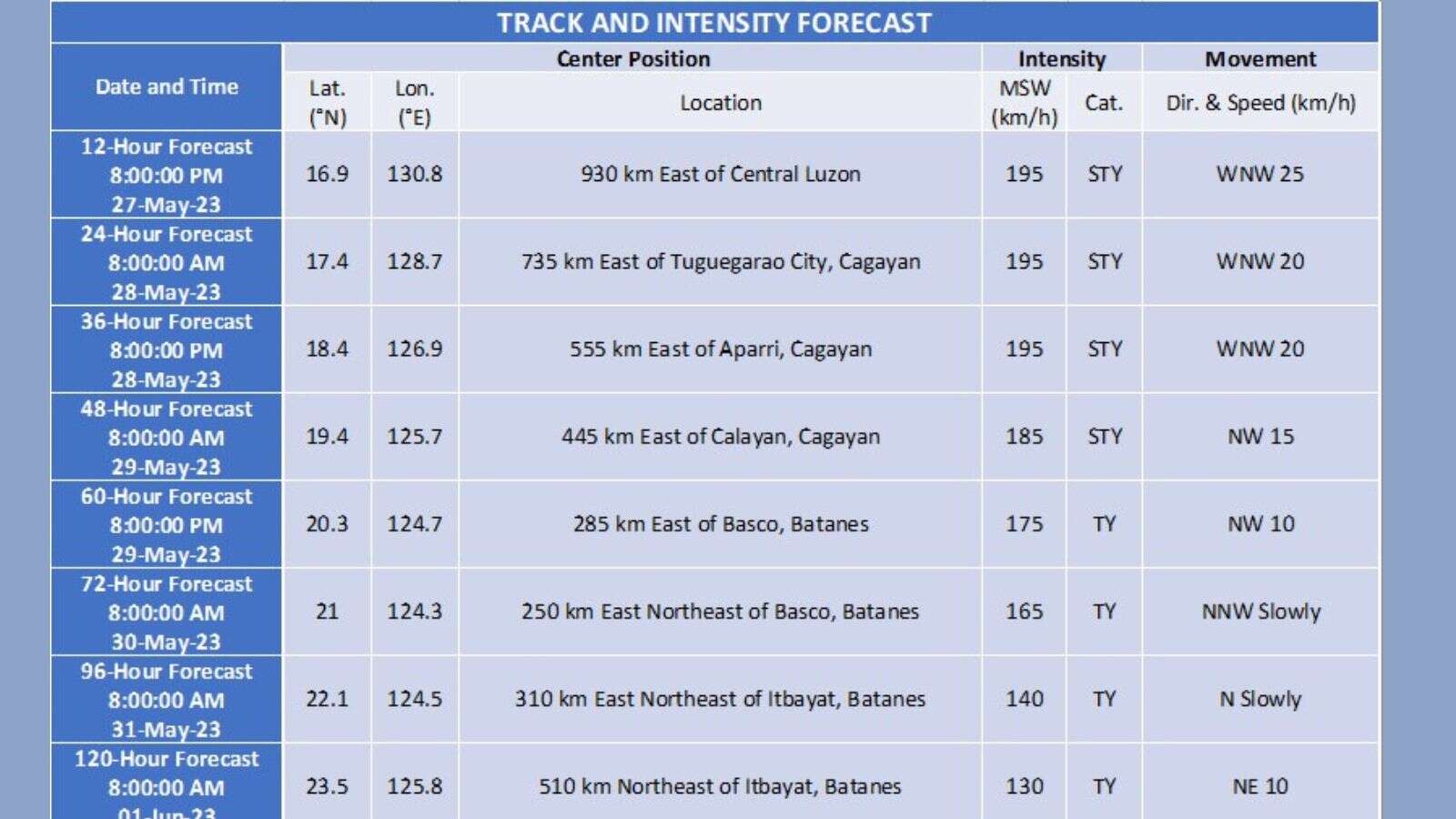
While it is anticipated to maintain its super typhoon status over the weekend, a short-term intensification over the next 12 to 24 hours is not ruled out. However, due to potential unfavorable conditions, including the upwelling of cooler ocean water and dry air intrusion, Betty may begin weakening considerably by Monday or Tuesday.
Stay safe and vigilant. The next tropical cyclone bulletin will be issued at 5:00 PM.
SOURCE: PAGASA
(adsbygoogle = window.adsbygoogle || []).push({});
For more information, see our complete guide on Typhoon Uwan Now Over La Union; Benguet still under Signal No. 4.


