Typhoon Lannie Slightly Accelerates; to Enter PAR Tonight
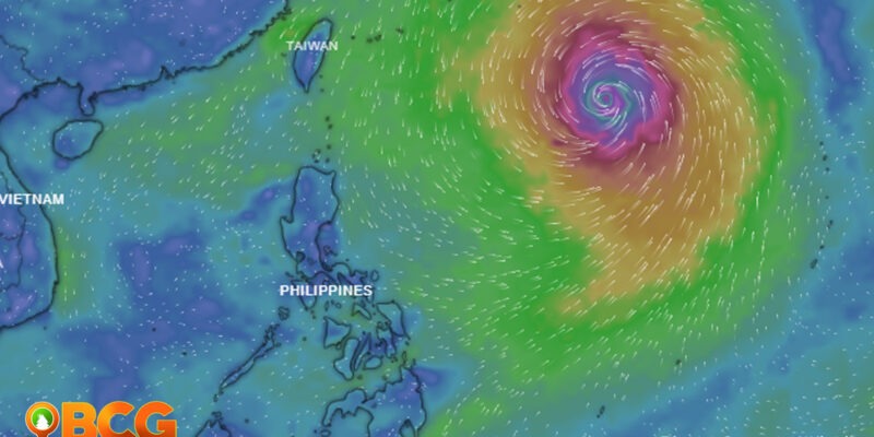
Typhoon “LANNIE,” with the international name “MINDULLE”, is expected to enter the Philippine Area of Responsibility (PAR) this evening. This report is according to the latest Tropical Cyclone Advisory released by the Philippine Atmospheric, Geophysical, and Astronomical Services Administration (PAGASA) on Tuesday.
Location of Center
Typhoon MINDULLE’s center of the eye is currently located outside of PAR, about 1,460 km East of Extreme Northern Luzon (21.3°N, 136.0°E). It has a maximum sustained winds of 165 km/h near the center, gustiness up to 205 km/h, and central pressure of 940 hPa.
Typhoon Forecast
- According to the weather bureau, MINDULLE will move generally north-northwestward or northwestward until Wednesday morning, northward for the remainder of Wednesday, then turn more northeastward on Thursday. Given this scenario, the typhoon may enter the Philippine Area of Responsibility (PAR) tonight or Wednesday morning and leave the area on Wednesday evening.
- Continuous intensification is forecast in the next 48 hours and may reach a peak intensity of around 185-195 km/h by Wednesday. Afterward, a general weakening trend will begin due to an increasingly unfavorable environment over the mid-latitude Pacific waters.
Typhoon LANNIE is unlikely to directly affect the weather condition of the country throughout the forecast period. In the next 24 hours, moderate to rough seas due to swells caused by the typhoon will be experienced over the seaboards of Extreme Northern Luzon and the northern and eastern seaboards of Luzon. These conditions are risky for those using small seacrafts. Mariners are advised to take precautionary measures when venturing out to sea and, if possible, avoid navigating in these conditions.
SOURCE: PAGASA


