
Tropical Storm ‘Aghon’ Intensifies: Heavy Rainfall and Strong Winds Expected in Quezon and Surrounding Areas
UPDATE June 3, 2026 10:58 AM:
(adsbygoogle = window.adsbygoogle || []).push({});
Heavy Rainfall Outlook:
Today to tomorrow noon:
200 mm: Quezon
100-200 mm: Aurora, the eastern portion of Bulacan, Rizal, Laguna, Metro Manila, and Camarines Norte
50-100 mm: The eastern portion of Isabela, Nueva Ecija, the rest of Bulacan, the eastern portion of Pampanga, Cavite, Batangas, Oriental Mindoro, Occidental Mindoro, Romblon, Burias Island, the western portion of Camarines Sur, Cuyo Islands, Aklan, and Antique
Tomorrow noon to Tuesday noon:
50-100 mm: The eastern portion of Isabela, the northern portion of Aurora, and Polillo Islands
Forecast rainfall is generally higher in elevated or mountainous areas. Under these conditions, flooding and rain-induced landslides are likely, especially in areas highly susceptible to these hazards and localities that have experienced significant rainfall in recent days.
(adsbygoogle = window.adsbygoogle || []).push({});
Tropical Cyclone Signals
Tropical Cyclone Wind Signal No. 2
: Gale-force winds
The northern and central portions of Quezon (Alabat, Perez, Quezon, Gumaca, Lopez, Macalelon, General Luna, Unisan, Pitogo, Plaridel, Agdangan, Padre Burgos, Atimonan, Mauban, Real, General Nakar, Infanta, Sampaloc, Pagbilao, Calauag, Lucban, City of Tayabas, Lucena City, Tiaong, Candelaria, Sariaya, Dolores, San Antonio) including Polillo Islands, Laguna, the eastern portion of Batangas (City of Tanauan, San Jose, Lipa City, Mataasnakahoy, Balete, Malvar, Santo Tomas, Cuenca, San Pascual, Batangas City, Ibaan, Padre Garcia, Rosario, San Juan, Taysan, Lobo) and the eastern portion of Rizal (Jala-Jala, Pililla, Tanay, Cardona, Binangonan, Morong, Baras)
Warning lead time: 24 hours
Range of wind speeds: 62 to 88 km/h (Beaufort 8 to 9)
Potential impacts of winds: Minor to moderate threat to life and property
Tropical Cyclone Wind Signal No. 1
: Strong winds
The southeastern portion of Isabela (Palanan, Dinapigue), the southern portion of Quirino (Maddela, Nagtipunan), the southern portion of Nueva Vizcaya (Alfonso Castaneda, Dupax del Sur, Dupax del Norte), the eastern and southern portions of Nueva Ecija (General Tinio, Gabaldon, Bongabon, Pantabangan, Rizal, General Mamerto Natividad, Laur, Palayan City, Peñaranda, San Leonardo, City of Gapan, Cabanatuan City, Santa Rosa, San Isidro, Cabiao, San Antonio, Jaen, Zaragoza, Aliaga, Talavera, Llanera), the southern portion of Bataan (Orani, Samal, City of Balanga, Abucay, Pilar, Orion, Limay, Mariveles, Bagac), Aurora, the eastern portion of Pampanga (Candaba, San Luis, San Simon, Apalit, Santa Ana, Arayat, Mexico, Santa Rita, Guagua, Sasmuan, Macabebe, Masantol, Santo Tomas, Minalin, City of San Fernando, Bacolor, Lubao), Bulacan, Metro Manila, the rest of Quezon, the rest of Rizal, Cavite, the rest of Batangas, the northern and central portions of Oriental Mindoro (Pinamalayan, Pola, Naujan, Victoria, Socorro, City of Calapan, Bansud, Gloria, Baco, San Teodoro, Puerto Galera, Bongabong), Marinduque, the extreme northern portion of Romblon (Concepcion, Corcuera, Banton), Camarines Norte, and Camarines Sur
Warning lead time: 36 hours
Range of wind speeds: 39 to 61 km/h (Beaufort 6 to 7)
Potential impacts of winds: Minimal to minor threat to life and property
Coastal Inundation:
There is a minimal to moderate risk of storm surge over the exposed and low-lying coastal areas of Cagayan, Isabela, Aurora, Central Luzon, Metro Manila, CALABARZON, Mindoro Provinces, Marinduque, Romblon, Camarines Norte, Camarines Sur, Albay (west coast), Burias Island, mainland Masbate (northwest coast), and Aklan within the next 24 hours. For detailed information, refer to Storm Surge Warning No. 1 issued at 8:00 AM today.
HAZARDS AFFECTING COASTAL WATERS
Under the influence of AGHON, a Gale Warning is hoisted over the coastal waters of Aurora, Quezon, Marinduque, the southern coastal waters of Batangas, and the northern coastal waters of Camarines Norte. Sea travel is risky for small seacrafts, including all motorbancas of any type of tonnage. For more information, refer to Gale Warning No. 2 (Intermediate) issued at 11:00 AM today.
Outside the Gale Warning areas, AGHON will bring moderate to rough seas (1.5 to 3.5 meters) over the coastal waters along the northern and eastern seaboards of Luzon and the seaboard of Bicol Region. Mariners of small vessels are advised to take precautionary measures while venturing out to sea and, if possible, avoid navigating in these conditions.
TRACK AND INTENSITY OUTLOOK
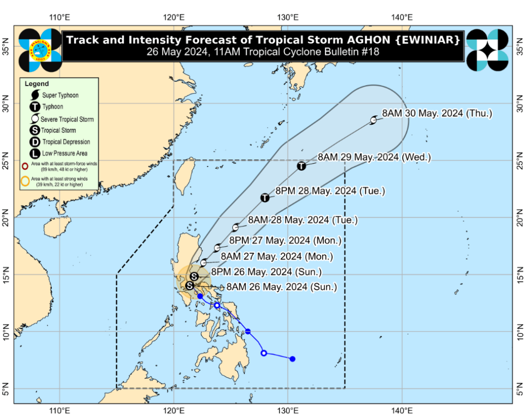
In the next 12 hours, AGHON will move across the landmass of mainland CALABARZON and Polillo Islands. The tropical storm is forecast to be over the waters off the east coast of Quezon or Aurora this evening or early tomorrow morning. During this period, AGHON is likely to remain a tropical storm, though weakening into a tropical depression while over mainland CALABARZON is not ruled out due to land interaction.
From Monday onwards, AGHON will gradually accelerate northeastward while intensifying. It is forecast to reach severe tropical storm category on Monday and potentially reach Typhoon category by Tuesday afternoon or evening, with a possible exit from the PAR region on Wednesday.
CURRENT LOCATION AND MOVEMENT
Location of Eye/Center: The center of Tropical Storm AGHON was estimated based on all available data, including those from Tagaytay Doppler Weather Radar, in the vicinity of Sariaya, Quezon (14.0 °N, 121.5 °E).
Movement: Moving Northwestward at 10 km/h.
Strength: Maximum sustained winds of 75 km/h near the center and gustiness of up to 125 km/h.
(adsbygoogle = window.adsbygoogle || []).push({});
For more information, see our complete guide on Typhoon Uwan Now Over La Union; Benguet still under Signal No. 4.


