
Aghon maintains strength as it continues to move northwest
UPDATE May 13, 2026 11:24 AM:
(adsbygoogle = window.adsbygoogle || []).push({});
Tropical Depression “Aghon” maintains its strength and is now positioned over the coastal waters of Catbalogan City, Samar.
Forecast Accumulated Rainfall:
From tonight until tomorrow evening:
100-200 mm: Albay, Sorsogon, Camarines Sur, Northern Samar, Samar, Eastern Samar, Biliran, and Leyte.
50-100 mm: Romblon, Southern Leyte, the southern portion of Quezon, the rest of Bicol Region, and the northern portions of Western Visayas and Cebu.
From tomorrow evening to Sunday evening:
100-200 mm: Camarines Norte, Camarines Sur, and Catanduanes.
50-100 mm: Northern Samar, Polillo Islands, the rest of Bicol Region, and the southern portion of Quezon.
From Sunday evening to Monday evening:
50-100 mm: Catanduanes, Camarines Norte, Camarines Sur, and the southern portion of Quezon and Polillo Islands.
Note: Rainfall amounts are generally higher in elevated or mountainous areas. Flooding and rain-induced landslides are possible, especially in areas highly susceptible to these hazards as identified in local hazard maps and regions that have experienced significant rainfall in recent days.
Tropical Cyclone Wind Signal
Tropical Cyclone Wind Signal No. 1
Luzon
The northern portion of Aurora (Casiguran, Dilasag), Polillo Islands, the southern portion of Quezon (Calauag, Guinayangan, Lopez, Buenavista, Catanauan, Mulanay, San Narciso, San Francisco, San Andres, Tagkawayan, Gumaca, Quezon, Alabat, Perez, Plaridel, Pitogo, Macalelon, General Luna, Atimonan, Unisan), the eastern portion of Romblon (Cajidiocan, Magdiwang, San Fernando), Camarines Norte, Camarines Sur, Catanduanes, Albay, Sorsogon, and Masbate including Burias and Ticao Islands
Visayas
Northern Samar, Samar, Eastern Samar, Biliran, Leyte, Southern Leyte, and the extreme northern portion of Cebu (San Remigio, Tabogon, City of Bogo, Medellin, Daanbantayan, Borbon) including Camotes and Bantayan Islands
Mindanao
Dinagat Islands
Hazards Affecting Coastal Waters:
Today: Aghon will bring moderate to rough seas (1.5 to 3.5 m) over the coastal waters along the seaboards of the Bicol Region, the southern seaboard of Quezon, the eastern seaboard of Eastern Visayas, the western seaboard of Samar and Northern Samar, and the eastern seaboard of Caraga Region. Mariners operating small vessels are advised to take precautionary measures and avoid navigating in these conditions if possible.
Track and Intensity Outlook:
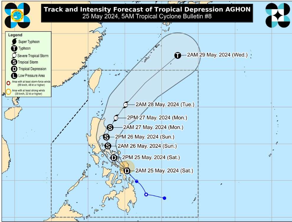
Aghon is forecast to move generally northwestward over the Samar Sea and cross the Bicol Peninsula between this afternoon and tomorrow early morning. It is expected to emerge over the waters north of the Camarines Provinces by tomorrow morning. During this period, Aghon may intensify to a tropical storm category.
By tomorrow afternoon, Aghon will begin to recurve towards the northeast, intensifying further and potentially reaching typhoon category by Tuesday. Aghon is expected to exit the Philippine Area of Responsibility (PAR) no earlier than Tuesday.
Location of Eye/Center:
The center of Aghon is currently located over the coastal waters of Catbalogan City, Samar (11.7 °N, 124.9 °E).
Movement:
Moving northwestward at 30 km/h.
Strength:
Maximum sustained winds of 55 km/h near the center, with gusts up to 70 km/h.
(adsbygoogle = window.adsbygoogle || []).push({});
For more information, see our complete guide on 10 Things You Can Do to Keep Your Cool This Summer.
For more information, see our complete guide on Typhoon Quinta.


