

 By
By Inday Enters PAR as Super Typhoon; Signal No. 1 Raised in Parts of Northern Luzon
Excerpt:
Super Typhoon Inday has entered the Philippine Area of Responsibility and may come nearest to Extreme Northern Luzon by Friday, July 10. Tropical Cyclone Wind Signal No. 1 is now raised over Batanes, Cagayan including Babuyan Islands, parts of Isabela, Apayao, parts of Kalinga, Aurora, and Catanduanes.
Super Typhoon Inday Now Inside PAR
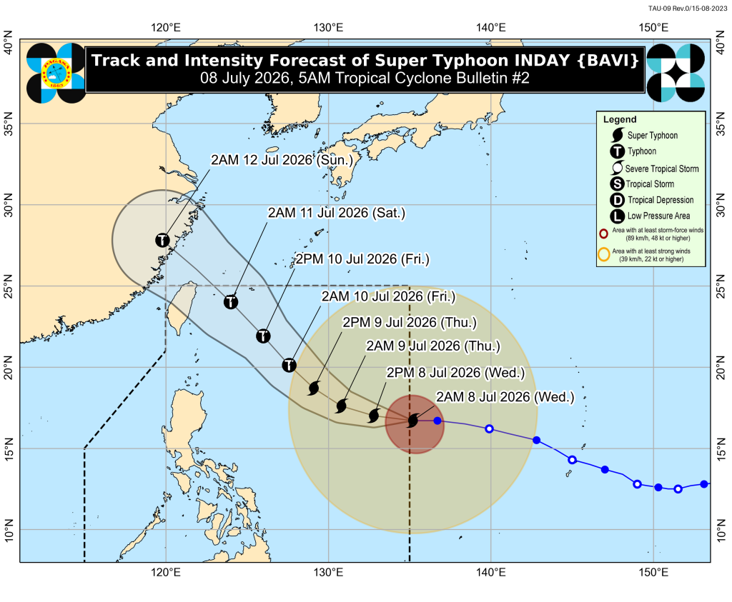
Super Typhoon Inday is now inside the Philippine Area of Responsibility, according to the 5:00 AM bulletin issued on July 8, 2026.
As of the latest update, the center of the eye of Inday was located at 1,405 km east of Northern Luzon.
Inday is currently moving westward at 25 km/h.
It has maximum sustained winds of 185 km/h near the center and gustiness of up to 230 km/h.
Tropical Cyclone Wind Signal No. 1 Areas
The following areas are under Tropical Cyclone Wind Signal No. 1:
Luzon
- Batanes
- Cagayan including Babuyan Islands
- Apayao
- Northern and central portions of Isabela:
- Santo Tomas
- Aurora
- Santa Maria
- Quezon
- San Mariano
- Naguilian
- Dinapigue
- Roxas
- Luna
- Delfin Albano
- City of Cauayan
- San Pablo
- Ilagan City
- Benito Soliven
- Tumauini
- Cabagan
- Reina Mercedes
- San Manuel
- Palanan
- Cabatuan
- Quirino
- Divilacan
- Gamu
- Mallig
- Maconacon
- Burgos
- San Guillermo
- Angadanan
- Alicia
- San Mateo
- Eastern portion of Kalinga:
- Pinukpuk
- City of Tabuk
- Rizal
- Northern portion of Aurora:
- Dilasag
- Northern and central portions of Catanduanes:
- Pandan
- Caramoran
- Bagamanoc
- Panganiban
- Viga
- Gigmoto
- Baras
- San Miguel
What Signal No. 1 Means
Areas under Signal No. 1 may experience winds of 39 to 61 km/h within at least 36 hours.
Possible impacts include:
- Very light or no damage to low-risk structures
- Light damage to medium to high-risk structures
- Slight damage to houses made of very light materials
- Some banana plants may be tilted or damaged
- Twigs of small trees may be broken
- Rice crops may suffer damage, especially if in flowering stage
PAGASA said the highest wind signal that may be hoisted during Inday’s passage is Signal No. 2 or Signal No. 3.
Strong Gusts Expected Due to Inday and Habagat
The enhanced Southwest Monsoon and the outer circulation of Super Typhoon Inday may bring strong to gale-force gusts, especially in coastal and upland areas exposed to winds.
Today, July 8
Strong to gale-force gusts may affect:
- Pangasinan
- Zambales
- Bataan
- CALABARZON
- Most of MIMAROPA
- Bicol Region
- Most of Visayas
- Most of Mindanao
Tomorrow, July 9
- Most of the country may experience strong to gale-force gusts.
Friday, July 10
- Most of the country may still experience strong to gale-force gusts.
Sea Travel Advisory
A Gale Warning will be issued over the northern and eastern seaboards of Luzon and Visayas.
Sea travel is risky for all types of vessels in areas with very rough seas. Mariners are advised to remain in port or seek shelter as soon as possible.
Very Rough Seas, Up to 4.5 Meters
Sea travel is risky for all vessel types in the following coastal waters:
- Seaboard of Isabela
- Northern seaboard of Aurora
- Northern and eastern seaboards of Catanduanes
- Eastern seaboard of Northern Samar
Rough Seas, Up to 4.0 Meters
Small seacrafts, including motorbancas, are advised not to venture out to sea in the following areas:
- Northern and eastern seaboards of Batanes
- Northern and eastern seaboards of Polillo Islands
- Eastern seaboard of Cagayan
- Eastern seaboard of Albay
- Eastern seaboard of Sorsogon
- Eastern seaboard of Eastern Samar
- Eastern seaboard of Dinagat Islands
- Remaining seaboard of Aurora
- Northern seaboard of mainland Quezon
- Northern seaboard of Camarines Norte
- Northern seaboard of Camarines Sur
- Northern seaboard of Northern Samar
Rough Seas, Up to 3.5 Meters
- Remaining seaboards of Batanes and Cagayan
- Eastern seaboards of Bucas Grande-Siargao Islands
- Eastern seaboard of Surigao del Sur
- Eastern and southern seaboards of Davao Oriental
Moderate to Rough Seas, Up to 2.5 Meters
- Southern seaboard of Southern Leyte
- Remaining seaboards of Surigao del Norte
- Southeastern seaboard of Davao Occidental
- Northern and western seaboards of Kalayaan
Moderate to Rough Seas, Up to 2.0 Meters
- Southern seaboard of Bohol
- Northern seaboard of Camiguin
- Remaining seaboards of Kalayaan Islands
Mariners using motorbancas and similarly sized vessels are advised to take precautionary measures and avoid sea travel when possible.
Forecast Track of Super Typhoon Inday
Inday is forecast to move generally westward in the next 24 hours. It may then turn northwestward while remaining over the Philippine Sea.
The super typhoon may come nearest to Extreme Northern Luzon by Friday, July 10.
It is forecast to exit the Philippine Area of Responsibility by Saturday, July 11, before moving toward the southern islands of Japan and the sea north of Taiwan. It may make landfall over the eastern coast of mainland China by Sunday, July 12.
Forecast Positions
- July 8, 2026, 2:00 PM: 1,185 km east of Northern Luzon
- July 9, 2026, 2:00 AM: 960 km east of Northern Luzon
- July 9, 2026, 2:00 PM: 805 km east of Extreme Northern Luzon
- July 10, 2026, 2:00 AM: 590 km east of Basco, Batanes
- July 10, 2026, 2:00 PM: 450 km east northeast of Itbayat, Batanes
- July 11, 2026, 2:00 AM: 420 km north northeast of Itbayat, Batanes
- July 12, 2026, 2:00 AM: 810 km north northwest of Extreme Northern Luzon, outside PAR
Intensity Outlook
Inday is expected to maintain super typhoon strength until Thursday, July 9.
It may weaken into a typhoon by Thursday afternoon or evening. However, it is still expected to remain a typhoon throughout the forecast period.
What Residents Should Do
Residents in affected areas are advised to:
- Monitor the latest bulletins from PAGASA
- Inspect houses for needed repairs
- Clean drainage systems
- Secure loose outdoor items
- Harvest crops that can already be yielded
- Avoid sea travel in areas with rough to very rough seas
- Prepare for possible stronger winds if the wind signal is upgraded
- Stay alert for flooding and landslides, especially in vulnerable areas
Disaster preparedness is now activated to alert status in areas under Tropical Cyclone Wind Signal No. 1.
Source: PAGASA Tropical Cyclone Bulletin for Super Typhoon Inday, issued 5:00 AM, July 8, 2026.
Background & Context
In general, tropical cyclone advisories like this one are crucial for informing the public about potential weather hazards. Residents in affected areas are typically advised to prepare for possible disruptions, including power outages and transportation issues. Local government units often activate disaster preparedness protocols to ensure community safety.
Related from Baguio City Guide
- Super Typhoon Bavi Now Named Inday; Signal No. 1 Raised Over Parts of Cagayan
- Super Typhoon Bavi Slightly Weakens, May Enter PAR Tonight or Early Wednesday
- Super Typhoon Bavi May Enter PAR as Inday Between July 7 and 8
For more information, see our complete guide on Typhoon Uwan Now Over La Union; Benguet still under Signal No. 4.





