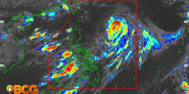
Typhoon “Chedeng” Continues to Hold Strength Over Philippine Sea
Typhoon “Chedeng,” internationally known as Guchol, continues to maintain its strength while moving slowly northward over the Philippine Sea, according to the latest bulletin from the Philippine Atmospheric, Geophysical, and Astronomical Services Administration (PAGASA).
Tap to Read More
Current Status and Trajectory
As of 10:00 AM today, the eye of Typhoon Chedeng was located approximately 880 km east of Northern Luzon or 840 km east of Extreme Northern Luzon. The storm retains maximum sustained winds of 150 km/h near the center and gustiness of up to 185 km/h. The central pressure remains at 955 hPa.
The typhoon is currently moving northward slowly, with strong to typhoon-force winds extending up to 520 km from the center. No wind signals have been hoisted at this time.
Impact on Land and Coastal Areas
Rainfall and Wind Projections
Despite Chedeng’s unlikely chance to directly cause heavy rainfall over the country within the next three days, the typhoon could enhance the Southwest Monsoon. This can result in occasional rains over the western portions of Luzon and Visayas in the coming days.
Additionally, the enhancement of the Southwest Monsoon may lead to gusty conditions over the next three days, particularly in areas like Metro Manila, CALABARZON, MIMAROPA, Bicol Region, Visayas, and other specified areas that are especially exposed to winds.
Sea Conditions
Mariners are alerted that Chedeng may bring moderate to rough seas (2.0 to 3.5 m) over the seaboards of Extreme Northern Luzon and the eastern seaboard of mainland Northern Luzon in the next 24 hours. Small seacraft operators are advised to take precautionary measures when venturing out to sea, and inexperienced or ill-equipped vessels should avoid navigating in these conditions.
Future Predictions for Path and Intensity
On the forecast track, Chedeng is predicted to remain far from the Philippine landmass. It is expected to continue its northward or north-northeastward motion today through tomorrow morning before turning generally northeastward. Thereafter, Chedeng will accelerate towards the sea southeast of Japan and east of the Ryukyu Islands, with a possible exit from the Philippine Area of Responsibility (PAR) between tomorrow late evening or early Monday morning.
The typhoon is expected to maintain its strength within the next 12 hours before entering a weakening trend tomorrow. However, Chedeng is forecast to remain a typhoon within the forecast period.
[/read more]


