Tropical Storm “Chedeng” Intensifies Over Philippine Sea, Remains at a Safe Distance
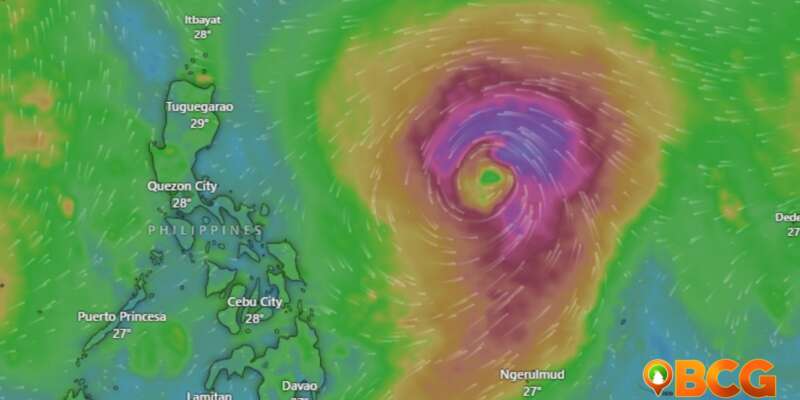
Tropical Storm “Chedeng” continues to gain strength over the Philippine Sea, reported the Philippine Atmospheric, Geophysical, and Astronomical Services Administration (PAGASA) early today. However, it poses no immediate threat to the country.
Current Status
As of 4:00 AM, Chedeng was estimated at about 1,060 km East of Southeastern Luzon. It is presently showing maximum sustained winds of 75 km/h near the center, gustiness reaching up to 90 km/h, and a central pressure of 998 hPa. The tropical storm is moving west-northwestward at 10 km/h. No tropical cyclone wind signals have been hoisted yet.
Rainfall and Wind Projections
PAGASA does not anticipate Chedeng to bring heavy rainfall over any part of the country in the next 3 to 5 days. Still, it warns that Chedeng might enhance the Southwest Monsoon, potentially changing the timing and intensity of rains, particularly in the country’s western parts. PAGASA advises the public to stay alert for updates on this potential development.
Similarly, severe winds associated with Chedeng are unlikely at this time. The strengthening of the Southwest Monsoon, however, could result in intermittent wind gusts. The public is urged to stay updated regarding possible monsoon enhancements.
Coastal Water Conditions
For the next 24 hours, Chedeng is not expected to cause rough sea conditions across the country’s coastal waters.
Track and Intensity Outlook
As Chedeng continues its intensifying trajectory, it is predicted to move northwestward or west-northwestward today through mid-Friday, before turning more northward or north-northeastward over the weekend. Throughout this period, Chedeng will stay far from the Philippine landmass.
Given the favorable environmental conditions, PAGASA expects Chedeng to intensify further in the next 3 to 4 days and possibly upgrade to a severe tropical storm tonight or tomorrow, potentially reaching typhoon status by Thursday. Its peak intensity could be reached by Friday or Saturday.
PAGASA urges the public and disaster risk reduction and management offices to take necessary precautions to safeguard lives and properties. Particularly, those living in areas highly or very highly susceptible to these hazards should follow instructions from local officials. For specific severe weather information, the public is encouraged to monitor updates from their local PAGASA Regional Services Division.
The next bulletin on Tropical Storm Chedeng will be issued at 11:00 AM today.


