
Goring slightly intensified, several areas under signal no. 1
UPDATE May 20, 2026 11:17 AM:
(adsbygoogle = window.adsbygoogle || []).push({});
Tropical Cyclone Goring is gradually intensifying as it continues its slow southwestward movement. Here’s what you need to know:
Land Hazards:
- Heavy Rainfall Predictions:
- Today: 50-100 mm expected in Batanes, Babuyan Islands, and the northeastern part of mainland Cagayan.
- Tomorrow: 50-100 mm anticipated for Babuyan Islands, and the eastern parts of mainland Cagayan and Isabela.
- Sunday: 50-100 mm forecasted for the northern section of Aurora and the eastern areas of Cagayan and Isabela.
Elevated or mountainous regions may experience even higher rainfall. Given these conditions, there’s a potential for flooding and rain-induced landslides, especially in areas identified as highly susceptible in hazard maps or those that have received significant rainfall recently.
- Southwest Monsoon Impact: The Southwest Monsoon, enhanced by Goring, will bring sporadic rains over the western parts of Central and Southern Luzon starting tomorrow, and over the western Visayas from Sunday. For a detailed update, refer to Weather Advisory #1 for the Southwest Monsoon and the 24-Hour Public Weather Forecast and Outlook.
- Severe Winds: Areas under Wind Signal No.1 might experience minimal to minor impacts from strong winds. Coastal and mountainous areas exposed to these winds might experience slightly stronger conditions, while sheltered areas will have milder winds. The enhanced Southwest Monsoon will also bring gusty conditions to several regions, including Aurora, Bataan, Metro Manila, CALABARZON, and more.
(adsbygoogle = window.adsbygoogle || []).push({});
Areas Under Tropical Cyclone Wind Signal No. 1:
- Batanes
- Eastern portion of Babuyan Islands:
- Babuyan Is.
- Camiguin Is.
- Eastern portion of mainland Cagayan:
- Santa Ana
- Gonzaga
- Lal-Lo
- Gattaran
- Baggao
- Peñablanca
- Northeastern portion of Isabela:
- Maconacon
- Divilacan
- Palanan
Coastal Hazards:
A Coastal Gale Warning has been issued for Batanes, Babuyan, and the northern coast of mainland Cagayan due to Goring’s strong winds. This makes sea travel risky for certain vessels, leading to potential disruptions in maritime activities. For more details, refer to Coastal Gale Warning #1.
Goring’s Path and Intensity:
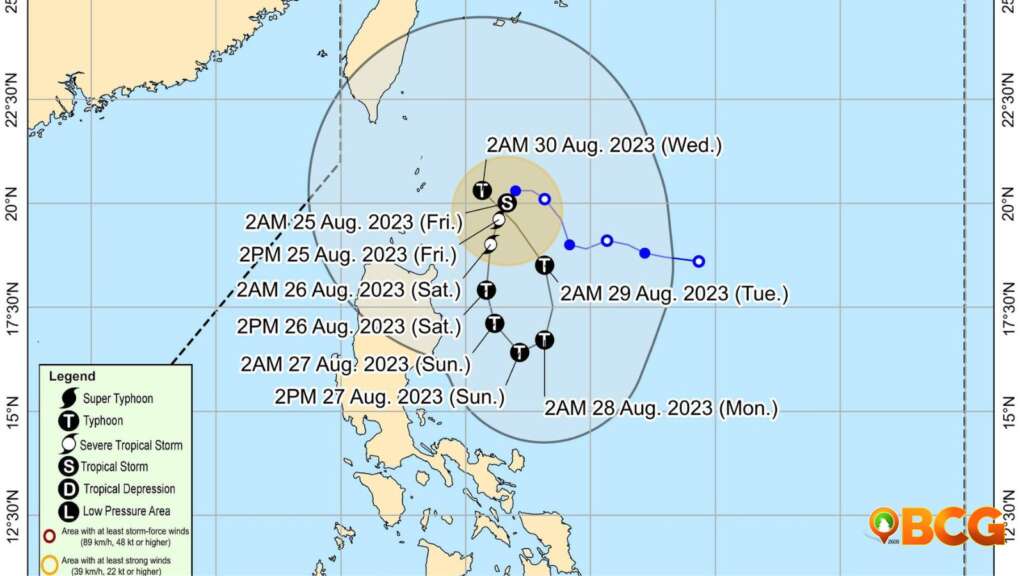
Goring is predicted to move south-southwestward near Northern Luzon until tomorrow afternoon, then shift southeastward through Sunday afternoon. It’s expected to loop northward and then northwest towards the Luzon Strait by Tuesday. The cyclone’s movement will remain slow for most of the forecast period.
With a conducive environment, Goring is likely to intensify rapidly, possibly reaching typhoon status by tomorrow. It’s expected to peak on Sunday evening and maintain its strength thereafter. The possibility of it becoming a super typhoon isn’t dismissed.
(adsbygoogle = window.adsbygoogle || []).push({});
Current Status of Goring:
- Location: 220 km East Southeast of Basco, Batanes (20.2 °N, 124.2 °E)
- Movement: Southwestward, slowly.
- Strength: Maximum sustained winds of 75 km/h near the center with gustiness reaching up to 90 km/h.
Active Tropical Cyclone Outside PAR (As of 3:00 AM Today):
- Tropical Storm DAMREY (2310)
- Location: 3,065 km east of Northern Luzon (16.0°N, 150.5°E)
- Maximum Sustained Winds: 65 km/h near the center
- Gustiness: Up to 80 km/h
- Movement: East northeastward at 35 km/h
(adsbygoogle = window.adsbygoogle || []).push({});
For more information, see our complete guide on List of Open Establishments, Operating Hours and Mode of Service.


