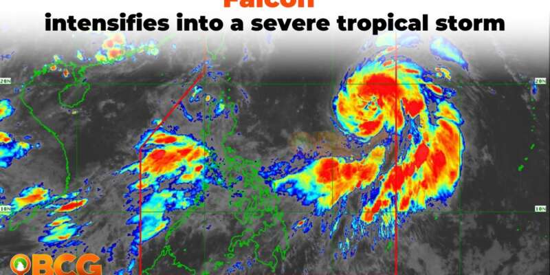
Falcon intensifies into a severe tropical storm
Severe Tropical Storm FALCON has intensified further while traversing the Philippine Sea. As of 4:00 AM, its center was estimated approximately 1,190 km East of Northern Luzon (17.8°N, 133.0°E). The storm now exhibits maximum sustained winds of 95 km/h near the center, with gusts reaching up to 115 km/h. Additionally, its central pressure has decreased to 985 hPa. Currently, FALCON is moving in a north-northwestward direction at a speed of 15 km/h.
Heavy Rainfall Outlook
The Southwest Monsoon, strengthened by Severe Tropical Storm FALCON, is expected to bring intermittent monsoon rains over the western parts of Luzon and Visayas in the next three days.
Severe Winds
As of the current forecast scenario, the likelihood of raising any Wind Signal due to FALCON over any locality in the country remains low. However, the enhanced Southwest Monsoon will bring gusty conditions over specific areas, especially in coastal and upland/mountainous regions exposed to winds, on the following days:
- Today: Zambales, Bataan, Pampanga, Bulacan, Metro Manila, Occidental Mindoro, Palawan, Romblon, Northern Samar, and most of CALABARZON, Bicol Region, and Western Visayas.
- Tomorrow: Ilocos Norte, Pangasinan, Zambales, Bataan, Pampanga, Bulacan, Metro Manila, Occidental Mindoro, Palawan, Romblon, Northern Samar, and most of CALABARZON, Bicol Region, and Western Visayas.
- Tuesday: Ilocos Region, Abra, Benguet, Zambales, Bataan, Bulacan, Metro Manila, Bicol Region, and most of CALABARZON, MIMAROPA, and Western Visayas.
Track and Intensity Outlook
- Over the Philippine Sea, FALCON is forecast to continue moving north-northwestward today, then turn northwestward tomorrow. Based on the current track forecast, the tropical storm may exit the Philippine Area of Responsibility (PAR) tomorrow evening or on Tuesday early morning. Beyond the PAR region, FALCON will then turn west-northwestward and pass close to the Okinawa Islands in the Ryukyu Archipelago on Tuesday morning before entering the East China Sea.
- FALCON is forecasted to continuously intensify over the next 3 days. It is projected to become a typhoon between late evening today or tomorrow early morning and reach its peak intensity on Tuesday.
The public and disaster risk reduction and management offices concerned are advised by PAGASA to take all necessary measures to protect life and property. Residents in areas identified as highly or very highly susceptible to these hazards are urged to follow evacuation and other instructions from local officials.
The next tropical cyclone bulletin will be issued at 11:00 AM today.


