
Severe Tropical Storm Paolo exits PAR, Parts of Benguet still under signal no.1
Severe Tropical Storm Paolo
Severe Tropical StormPaolo (MATMO) has moved out of the Philippine Area of Responsibility (PAR) early Friday morning. Despite exiting PAR, Paolo continues to enhance winds and coastal conditions in parts of Northern Luzon.
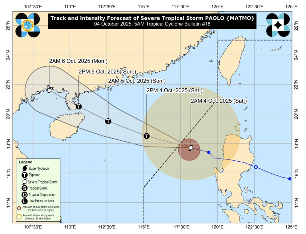
At 4:00 AM, the storm’s center was estimated at 295 km west of Sinait, Ilocos Sur (18.1°N, 117.7°E). It is moving west-northwest at 20 km/h with maximum sustained winds of 110 km/h near the center and gustiness reaching 135 km/h.
Track and Intensity Outlook
 Severe Tropical Storm Paolo " width="1024" height="784" class="aligncenter size-large wp-image-55447" />
- Paolo is forecast to continue moving west-northwestward over the West Philippine Sea toward southern China.
- The system is expected to re-intensify into a typhoon later today.
- Although outside PAR, Paolo’s outer rain bands and winds will continue to affect parts of Northern and Central Luzon.
Tropical Cyclone Wind Signals in Effect
Signal No. 1 (Strong winds: 39–61 km/h in 36 hours; minimal to minor threat to life and property)
- Abra (west): Danglas, Bangued, Langiden, San Quintin, Pidigan, San Isidro, Pilar, Villaviciosa, Peñarrubia, Manabo, Luba, Tayum, La Paz, Lagayan, Tubo, Bucay, Dolores, San Juan, Lagangilang
- Benguet (west): Bakun, Kibungan, Kapangan, Sablan, Tuba, Mankayan, Tublay, La Trinidad, Baguio City
- Ilocos Norte (south): Nueva Era, Banna, Badoc, Pinili, Batac City, Paoay, Marcos, Currimao
- Ilocos Sur
- La Union
- Pangasinan (west and central): Bolinao, Bani, Agno, Burgos, Dasol, Mabini, Infanta, Bugallon, Labrador, Sual, Alaminos City, Lingayen, Aguilar, Mangatarem, Urbiztondo, San Carlos City, Binmaley, Dagupan City, Calasiao, Basista, Bayambang, San Fabian, San Jacinto, Mangaldan, Mapandan, Sta. Barbara, Malasiqui, Alcala, Bautista, Sto. Tomas, Villasis, Urdaneta City, Manaoag, Laoac, Pozorrubio, Sison
- Zambales (north): Iba, Candelaria, Palauig, Sta. Cruz, Masinloc
Hazards Affecting Land Areas
Severe Winds
- Minimal to minor impacts are expected within areas under Signal No. 1.
- Strong to gale-force gusts may also affect Batanes, northern mainland Cagayan including Babuyan Islands, Apayao, Zambales, and Bataan, even if not under TCWS.
Coastal Inundation
- Storm surge of 1.0–2.0 meters is possible within 12 hours over low-lying coastal areas of Ilocos Norte, Ilocos Sur, La Union, Pangasinan, and Zambales.
Hazards Affecting Coastal Waters
Moderate to Rough Seas Expected:
- Up to 4.0 m: Seaboards of mainland Cagayan, Babuyan Islands, Ilocos Norte, Ilocos Sur, La Union
- Up to 3.5 m: Seaboards of Batanes and Pangasinan
- Up to 2.5 m: Seaboards of Isabela, northern Aurora, Zambales
- Up to 2.0 m: Remaining seaboards of Aurora, western Bataan, and Lubang Island
Mariners of motorbancas and small vessels are advised to avoid sea travel under these conditions.
Advisory
Although Paolo has exited PAR, its outer bands will continue to enhance rains, winds, and sea conditions in parts of Northern Luzon. Residents are urged to:
- Monitor advisories from PAGASA and local authorities.
- Stay away from coastal areas at risk of storm surge.
- Avoid unnecessary travel by land or sea until conditions improve.


