“MAWAR” Slightly Intensifies While Moving Westward over the Philippine Sea
Super Typhoon Threatens Northern Luzon, Intensifies as it Approaches Philippine Area of Responsibility
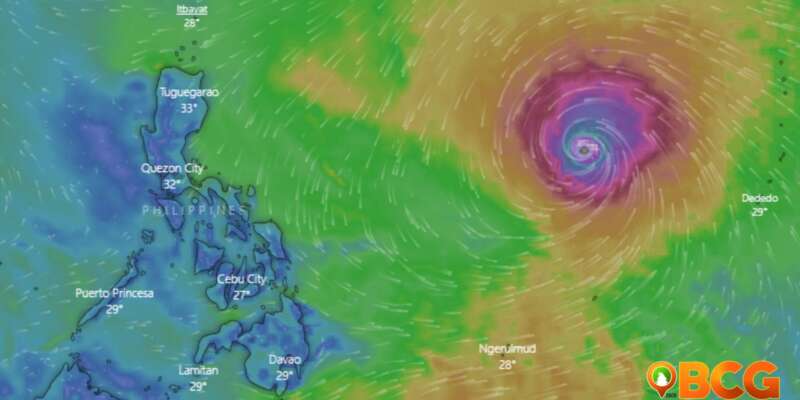
In the latest weather bulletin issued by the Philippine Atmospheric, Geophysical, and Astronomical Services Administration (PAGASA), Super Typhoon “MAWAR” has slightly intensified as it moves westward over the Philippine Sea. The powerful storm is expected to enter the Philippine Area of Responsibility (PAR) tonight or tomorrow morning.
At 10:00 AM today, the center of Super Typhoon “MAWAR” was estimated to be located approximately 1,705 kilometers east of Southeastern Luzon, specifically at coordinates 15.1°N and 138.8°E. The storm boasts maximum sustained winds of 215 km/h near the center, with gusts reaching up to 260 km/h. The central pressure was recorded at 905 hPa.
“MAWAR” is currently moving west at a speed of 20 km/h. The extent of its tropical cyclone winds is formidable, reaching outwards up to 550 km from the center. As it continues on its trajectory, the super typhoon is expected to track generally west-northwestward until Sunday, when it will begin to accelerate and turn northwestward. By next week, during the slowdown period, the center of MAWAR’s eye is projected to be within 250 km of the Batanes-Babuyan archipelago.
The forecast suggests that “MAWAR” will reach its peak intensity within the next 24 hours. Although a slight weakening may occur by tomorrow evening, the storm is expected to maintain its super typhoon status until Monday morning due to highly favorable environmental conditions. However, by late Monday or Tuesday, unfavorable factors such as increasing wind shear, cooler sea surface temperatures resulting from its slowdown, and dry air intrusion are expected to cause a faster weakening of the typhoon.
Furthermore, “MAWAR” is predicted to enhance the Southwest Monsoon, bringing monsoon rains over the western parts of Central Luzon, Southern Luzon, and Visayas starting Sunday or Monday.
Authorities are advising residents and disaster risk reduction and management offices to stay vigilant and closely monitor updates regarding “MAWAR.” The super typhoon poses a significant threat to Northern Luzon, particularly with heavy rains that may trigger flooding and rain-induced landslides. Starting late Sunday or Monday next week, the region may experience strong to storm-force conditions, while the northern and eastern portions of Northern Luzon mainland may encounter strong to gale-force winds. In preparation for these severe winds, wind signals will be raised tomorrow evening.


