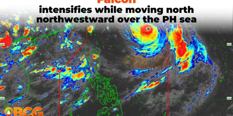
Falcon intensifies while moving north northwestward over the PH sea
Typhoon FALCON has further intensified as it continues to move north-northwestward over the Philippine Sea. As of 4:00 PM, the center of the typhoon’s eye was estimated approximately 1,020 km East Northeast of Extreme Northern Luzon (23.0°N, 131.4°E). It now has maximum sustained winds of 165 km/h near the center, with gusts reaching up to 205 km/h. Additionally, the central pressure is recorded at 940 hPa. FALCON is currently moving at a speed of 15 km/h.
Heavy Rainfall Outlook
The Southwest Monsoon, enhanced by Typhoon FALCON, will bring occasional to monsoon rains over the western portion of Luzon and Visayas in the next three days.
Forecasted rainfall is expected to be higher in elevated or mountainous areas, and under these conditions, flooding and rain-induced landslides are likely, especially in areas that are highly or very highly susceptible to such hazards, as indicated in hazard maps and in localities that have experienced considerable amounts of rainfall in recent days.
Severe Winds
The current forecast scenario suggests that the hoisting of any Wind Signal due to FALCON over any locality in the country remains unlikely. However, the enhanced Southwest Monsoon will bring gusty conditions over specific areas, especially in coastal and upland/mountainous regions exposed to winds, on the following days:
Today: Zambales, Bataan, the central and southern portions of Aurora, Pampanga, Bulacan, Metro Manila, and most of Ilocos Region, CALABARZON, MIMAROPA, Bicol Region, and Western Visayas.
Tomorrow: Batanes, Babuyan Islands, Abra, Benguet, Zambales, Bataan, the central and southern portions of Aurora, Pampanga, Bulacan, Metro Manila, and most of Ilocos Region, CALABARZON, MIMAROPA, Bicol Region, and Western Visayas.
Wednesday: Batanes, Babuyan Islands, Ilocos Region, Abra, Benguet, Aurora, Zambales, Bataan, Bulacan, Pampanga, Metro Manila, CALABARZON, MIMAROPA, Bicol Region, the western portion of Northern Samar, and most of Western Visayas.
Track and Intensity Outlook
- FALCON is forecast to steadily move north-northwestward or northwestward in the next 12 hours, then turn west-northwestward tomorrow over the Philippine Sea. Based on the current track forecast, the typhoon may exit the Philippine Area of Responsibility (PAR) between tomorrow afternoon and tomorrow evening. Beyond the PAR region, FALCON will then turn west-northwestward and pass close (landfall not ruled out) over Okinawa Islands in the Ryukyu Archipelago between tomorrow evening and Wednesday morning while gradually decelerating.
- FALCON is forecasted to further intensify in the next 12 hours and reach its peak intensity while maintaining its strength as it tracks over Okinawa Islands in the Ryukyu Archipelago.
Note: The next tropical cyclone bulletin will be issued at 5:00 AM tomorrow.


